Tesistán geodata
Tesistán (Jalisco) is a populated place; located in Mexico in America/Mexico_City (GMT-6) time zone. With population of 62,397 people, there are 188 cities with bigger population in this country. Compared to other cities in Mexico, 73.3% of cities are located further ↓South; 88.2% of cities are located further →East and 55.3% of cities have lower elevation than Tesistán. Note1


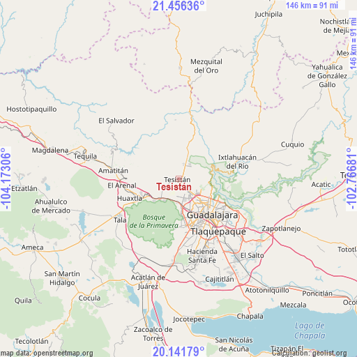
Tesistán GPS coordinates[2]
20° 48' 1.836" North, 103° 28' 11.748" West
| Map corner | latitude | longitude |
|---|---|---|
| Upper-left | 21.45636°, | -104.17306° |
| Center: | 20.80051°, | -103.46993° |
| Lower-right: | 20.14179°, | -102.76681° |
| Map W x H: | 146.2×146.2 km | = 90.8×90.8mi |
| max Lat: | 32.7° ⇑26.7% North |
| Tesistán: | 20.80051° |
| min Lat: | ⇓73.3% South 14.53588° |
| min Long | Tesistán | max Long |
| -117.105° | -103.46993° | -86.73105° |
| W 11.8%⇐ | ⇒88.2% E |
Elevation
Elevation of Tesistán is 1596 m = 5236 ft, and this is 342.3 m = 1123 ft above average elevation for this country.
| Max E: |
3497 m = 11473 ft | 44.7% |
| Tesistán | 1596 m 5236 ft | |
| Avg. | 1253.7 m = 4113 ft | |
Min E: |
-1 m = -3 ft | 55.3% |
See also: Tesistán elevation on elevation.city.
Geographical zone
Tesistán is located in North Torrid zone (between Equator and Tropic of Cancer). Distance of this Northern Tropic circle is 293.1 km =182.1 mi to North.| Distance of | km | miles | from Tesistán |
|---|---|---|---|
| North Pole | 7694.3 | 4781 | to North |
| Arctic Circle | 5088.4 | 3161.8 | to North |
| Tropic Cancer | 293.1 | 182.1 | to North |
| Equator | 2312.8 | 1437.1 | to South |


Nearby cities:
15 places around Tesistán: (largest is in red/bold)
• Campestre las Palomas [Fraccionamiento]
2.7 km =1.7 mi,  44°
44°
• Campo Real
3.2 km =2 mi,  117°
117°
• Guadalajara
16.9 km =10.5 mi,  151°
151°
• La Cuchilla (Extramuros de Tesistán)
2.4 km =1.5 mi,  160°
160°
• La Primavera
13.1 km =8.1 mi,  229°
229°
• La Venta del Astillero
11.2 km =7 mi,  224°
224°
• Nextipac
6.7 km =4.2 mi,  236°
236°
• Nuevo México
5.6 km =3.5 mi, 150°
• Pinar de la Venta
10.7 km =6.6 mi,  211°
211°
• Puerta del Llano
1.9 km =1.2 mi, 152°
• Rancho Contento
9.8 km =6.1 mi,  184°
184°
• San Esteban (San Miguel Tateposco)
9.9 km =6.2 mi,  91°
91°
• San Isidro
12.4 km =7.7 mi, 94°
• Zapopan
12.3 km =7.6 mi,  134°
134°
• Zapopan2
11.8 km =7.3 mi,  142°
142°
Sources, notices
• [Note1] Compared only with cities in Mexico existing in our database
• [Src1] Map data: © OpenStreetMap contributors (CC-BY-SA)
• [Src2] Other city data from geonames.org with taken over terms of usage.
• [Src3] Geographical zone / Annual Mean Temperature by Robert A. Rohde @ Wikipedia
