San Isidro Petlácatl geodata
San Isidro Petlácatl (Puebla) is a populated place; located in Mexico in America/Mexico_City (GMT-6) time zone. With population of 762 people, there are 11496 cities with bigger population in this country. Compared to other cities in Mexico, 65.5% of cities are located further ↑North; 59.9% of cities are located further ←West and 78.6% of cities have lower elevation than San Isidro Petlácatl. Note1
Current local time in San Isidro Petlácatl:
08:35 AM, WednesdayDifference from your time zone: hours


San Isidro Petlácatl GPS coordinates[2]
18° 57' 56.016" North, 98° 18' 1.008" West
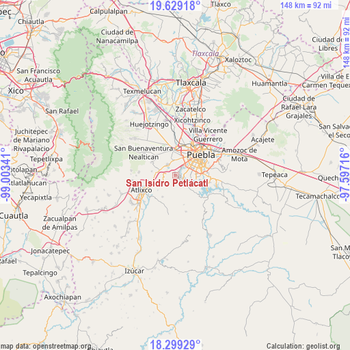
| Map corner | latitude | longitude |
|---|---|---|
| Upper-left | 19.62918°, | -99.00341° |
| Center: | 18.96556°, | -98.30028° |
| Lower-right: | 18.29929°, | -97.59716° |
| Map W x H: | 147.9×147.9 km | = 91.9×91.9mi |
| max Lat: | 32.7° ⇑65.5% North |
| San Isidro Petlácatl: | 18.96556° |
| min Lat: | ⇓34.5% South 14.53588° |
| min Long | San Isidro Petl | max Long |
| -117.105° | -98.30028° | -86.73105° |
| W 59.9%⇐ | ⇒40.1% E |
Elevation
Elevation of San Isidro Petlácatl is 2103 m = 6900 ft, and this is 849.3 m = 2786 ft above average elevation for this country.
| Max E: |
3497 m = 11473 ft | 21.4% |
| San Isidro Petlácatl | 2103 m 6900 ft | |
| Avg. | 1253.7 m = 4113 ft | |
Min E: |
-1 m = -3 ft | 78.6% |
See also: Mexico elevation on elevation.city.
Geographical zone
San Isidro Petlácatl is located in North Torrid zone (between Equator and Tropic of Cancer). Distance of this Northern Tropic circle is 497.1 km =308.9 mi to North.| Distance of | km | miles | from San Isidro Petlácatl |
|---|---|---|---|
| North Pole | 7898.3 | 4907.8 | to North |
| Arctic Circle | 5292.4 | 3288.5 | to North |
| Tropic Cancer | 497.1 | 308.9 | to North |
| Equator | 2108.8 | 1310.3 | to South |


Nearby cities:
15 places around San Isidro Petlácatl: (largest is in red/bold)
• Chalchihuapan
3.9 km =2.4 mi,  280°
280°
• Chipilo de Francisco Javier Mina
5.5 km =3.4 mi,  324°
324°
• El Capulo (La Quebradora)
3.8 km =2.4 mi,  118°
118°
• Emilio Portes Gil
7 km =4.3 mi,  228°
228°
• Francisco Sarabia
1.4 km =0.9 mi,  263°
263°
• San Andrés Azumiatla
8.5 km =5.3 mi,  143°
143°
• San Bernabé Temoxtitla
4.8 km =3 mi, 317°
• San Bernardino Tlaxcalancingo
7.4 km =4.6 mi,  19°
19°
• San Gregorio Atzompa
8.2 km =5.1 mi, 321°
• San José Zetina
5.7 km =3.5 mi,  150°
150°
• San Juan Portezuelo
7.7 km =4.8 mi, 230°
• San Pablo Ahuatempa
6.4 km =4 mi,  285°
285°
• Santa Clara
1.2 km =0.7 mi,  354°
354°
• Santa Martha Hidalgo
3.3 km =2.1 mi,  310°
310°
• Santa María Malacatepec
2.7 km =1.7 mi,  184°
184°
Sources, notices
• [Note1] Compared only with cities in Mexico existing in our database
• [Src1] Map data: © OpenStreetMap contributors (CC-BY-SA)
• [Src2] Other city data from geonames.org with taken over terms of usage.
• [Src3] Geographical zone / Annual Mean Temperature by Robert A. Rohde @ Wikipedia
