Las Grutas geodata
Las Grutas (Michoacán) is a populated place; located in Mexico in America/Mexico_City (GMT-6) time zone. With population of 757 people, there are 11569 cities with bigger population in this country. Compared to other cities in Mexico, 50.9% of cities are located further ↑North; 69.5% of cities are located further →East and 69.6% of cities have lower elevation than Las Grutas. Note1


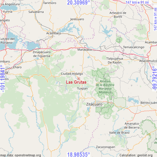
Las Grutas GPS coordinates[2]
19° 38' 56.004" North, 100° 29' 43.008" West
| Map corner | latitude | longitude |
|---|---|---|
| Upper-left | 20.30969°, | -101.19841° |
| Center: | 19.64889°, | -100.49528° |
| Lower-right: | 18.98535°, | -99.79216° |
| Map W x H: | 147.3×147.3 km | = 91.5×91.5mi |
| max Lat: | 32.7° ⇑50.9% North |
| Las Grutas: | 19.64889° |
| min Lat: | ⇓49.1% South 14.53588° |
| min Long | Las Grutas | max Long |
| -117.105° | -100.49528° | -86.73105° |
| W 30.5%⇐ | ⇒69.5% E |
Elevation
Elevation of Las Grutas is 1918 m = 6293 ft, and this is 664.3 m = 2179 ft above average elevation for this country.
| Max E: |
3497 m = 11473 ft | 30.4% |
| Las Grutas | 1918 m 6293 ft | |
| Avg. | 1253.7 m = 4113 ft | |
Min E: |
-1 m = -3 ft | 69.6% |
See also: Mexico elevation on elevation.city.
Geographical zone
Las Grutas is located in North Torrid zone (between Equator and Tropic of Cancer). Distance of this Northern Tropic circle is 421.2 km =261.7 mi to North.| Distance of | km | miles | from Las Grutas |
|---|---|---|---|
| North Pole | 7822.3 | 4860.6 | to North |
| Arctic Circle | 5216.4 | 3241.3 | to North |
| Tropic Cancer | 421.2 | 261.7 | to North |
| Equator | 2184.8 | 1357.6 | to South |


Nearby cities:
15 places around Las Grutas: (largest is in red/bold)
• Aquiles Córdova Morán
7.7 km =4.8 mi,  326°
326°
• Ciudad Hidalgo
7.9 km =4.9 mi,  308°
308°
• Cofradía de San José
8.3 km =5.2 mi,  148°
148°
• Colonia Antorcha Campesina (Santa Rosa)
4.7 km =2.9 mi,  316°
316°
• Colonia Aquiles Córdoba Morán
7.7 km =4.8 mi, 326°
• Colonia el Mirador (Llano del Ejido)
6.8 km =4.2 mi,  296°
296°
• El Jazmín
3.8 km =2.4 mi,  183°
183°
• Irimbo
6 km =3.7 mi,  16°
16°
• Magallanes (Los Pinos)
4.8 km =3 mi,  342°
342°
• Rincón de Cedeños (Rincón de Dolores)
9.1 km =5.7 mi,  290°
290°
• San Francisco Epunguio
8.2 km =5.1 mi,  46°
46°
• San José de Magallanes
4.4 km =2.7 mi,  350°
350°
• San Lorenzo Queréndaro
2.2 km =1.4 mi, 18°
• Santa Ana
7.9 km =4.9 mi,  159°
159°
• Turundeo
3.6 km =2.2 mi, 153°
Sources, notices
• [Note1] Compared only with cities in Mexico existing in our database
• [Src1] Map data: © OpenStreetMap contributors (CC-BY-SA)
• [Src2] Other city data from geonames.org with taken over terms of usage.
• [Src3] Geographical zone / Annual Mean Temperature by Robert A. Rohde @ Wikipedia
