Turundeo geodata
Turundeo (Michoacán) is a populated place; located in Mexico in America/Mexico_City (GMT-6) time zone. With population of 635 people, there are 13639 cities with bigger population in this country. Compared to other cities in Mexico, 51.5% of cities are located further ↑North; 69.3% of cities are located further →East and 63.7% of cities have lower elevation than Turundeo. Note1


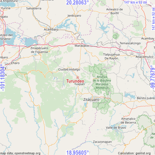
Turundeo GPS coordinates[2]
19° 37' 10.92" North, 100° 28' 47.676" West
| Map corner | latitude | longitude |
|---|---|---|
| Upper-left | 20.28063°, | -101.18304° |
| Center: | 19.6197°, | -100.47991° |
| Lower-right: | 18.95605°, | -99.77679° |
| Map W x H: | 147.3×147.3 km | = 91.5×91.5mi |
| max Lat: | 32.7° ⇑51.5% North |
| Turundeo: | 19.6197° |
| min Lat: | ⇓48.5% South 14.53588° |
| min Long | Turundeo | max Long |
| -117.105° | -100.47991° | -86.73105° |
| W 30.7%⇐ | ⇒69.3% E |
Elevation
Elevation of Turundeo is 1794 m = 5886 ft, and this is 540.3 m = 1773 ft above average elevation for this country.
| Max E: |
3497 m = 11473 ft | 36.3% |
| Turundeo | 1794 m 5886 ft | |
| Avg. | 1253.7 m = 4113 ft | |
Min E: |
-1 m = -3 ft | 63.7% |
See also: Mexico elevation on elevation.city.
Geographical zone
Turundeo is located in North Torrid zone (between Equator and Tropic of Cancer). Distance of this Northern Tropic circle is 424.4 km =263.7 mi to North.| Distance of | km | miles | from Turundeo |
|---|---|---|---|
| North Pole | 7825.6 | 4862.6 | to North |
| Arctic Circle | 5219.7 | 3243.4 | to North |
| Tropic Cancer | 424.4 | 263.7 | to North |
| Equator | 2181.5 | 1355.5 | to South |


Nearby cities:
15 places around Turundeo: (largest is in red/bold)
• Aporo
9.2 km =5.7 mi,  52°
52°
• Cerrito Colorado
7.9 km =4.9 mi,  197°
197°
• Cofradía de San José
4.7 km =2.9 mi,  144°
144°
• Colonia Antorcha Campesina (Santa Rosa)
8.3 km =5.2 mi,  324°
324°
• Colonia Puerto del Obispo
9.5 km =5.9 mi,  170°
170°
• El Jazmín
1.9 km =1.2 mi,  253°
253°
• El Malacate
8.7 km =5.4 mi,  176°
176°
• Irimbo
9 km =5.6 mi,  0°
0°
• Las Grutas
3.6 km =2.2 mi,  333°
333°
• Magallanes (Los Pinos)
8.4 km =5.2 mi,  338°
338°
• San José de Magallanes
7.9 km =4.9 mi, 343°
• San Lorenzo Queréndaro
5.4 km =3.4 mi,  350°
350°
• Santa Ana
4.3 km =2.7 mi,  164°
164°
• Santa Catarina
7.9 km =4.9 mi, 174°
• Tuxpan
6.1 km =3.8 mi, 161°
Sources, notices
• [Note1] Compared only with cities in Mexico existing in our database
• [Src1] Map data: © OpenStreetMap contributors (CC-BY-SA)
• [Src2] Other city data from geonames.org with taken over terms of usage.
• [Src3] Geographical zone / Annual Mean Temperature by Robert A. Rohde @ Wikipedia
