Magallanes (Los Pinos) geodata
Magallanes (Los Pinos) (Michoacán) is a populated place; located in Mexico in America/Mexico_City (GMT-6) time zone. With population of 524 people, there are 16113 cities with bigger population in this country. Compared to other cities in Mexico, 50.1% of cities are located further ↓South; 69.6% of cities are located further →East and 75.3% of cities have lower elevation than Magallanes (Los Pinos). Note1
Current local time in Magallanes (Los Pinos):
12:52 AM, WednesdayDifference from your time zone: hours


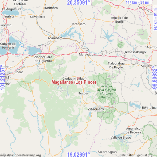
Magallanes (Los Pinos) GPS coordinates[2]
19° 41' 25.008" North, 100° 30' 33.984" West
| Map corner | latitude | longitude |
|---|---|---|
| Upper-left | 20.35091°, | -101.21257° |
| Center: | 19.69028°, | -100.50944° |
| Lower-right: | 19.02691°, | -99.80632° |
| Map W x H: | 147.2×147.2 km | = 91.5×91.5mi |
| max Lat: | 32.7° ⇑49.9% North |
| Magallanes (Los Pinos): | 19.69028° |
| min Lat: | ⇓50.1% South 14.53588° |
| min Long | Magallanes (Los | max Long |
| -117.105° | -100.50944° | -86.73105° |
| W 30.4%⇐ | ⇒69.6% E |
Elevation
Elevation of Magallanes (Los Pinos) is 2035 m = 6677 ft, and this is 781.3 m = 2563 ft above average elevation for this country.
| Max E: |
3497 m = 11473 ft | 24.7% |
| Magallanes (Los Pinos) | 2035 m 6677 ft | |
| Avg. | 1253.7 m = 4113 ft | |
Min E: |
-1 m = -3 ft | 75.3% |
See also: Mexico elevation on elevation.city.
Geographical zone
Magallanes (Los Pinos) is located in North Torrid zone (between Equator and Tropic of Cancer). Distance of this Northern Tropic circle is 416.6 km =258.9 mi to North.| Distance of | km | miles | from Magallanes (Los Pinos) |
|---|---|---|---|
| North Pole | 7817.7 | 4857.7 | to North |
| Arctic Circle | 5211.8 | 3238.5 | to North |
| Tropic Cancer | 416.6 | 258.9 | to North |
| Equator | 2189.4 | 1360.4 | to South |


Nearby cities:
15 places around Magallanes (Los Pinos): (largest is in red/bold)
• Aquiles Córdova Morán
3.3 km =2.1 mi,  303°
303°
• Ciudad Hidalgo
4.7 km =2.9 mi,  273°
273°
• Colonia Antorcha Campesina (Santa Rosa)
2.1 km =1.3 mi,  236°
236°
• Colonia Aquiles Córdoba Morán
3.3 km =2.1 mi, 303°
• Colonia el Mirador (Llano del Ejido)
4.9 km =3 mi,  250°
250°
• El Jazmín
8.5 km =5.3 mi,  171°
171°
• Irimbo
3.4 km =2.1 mi,  70°
70°
• Las Grutas
4.8 km =3 mi,  162°
162°
• Rincón de Cedeños (Rincón de Dolores)
7.1 km =4.4 mi,  259°
259°
• San Francisco Epunguio
7.5 km =4.7 mi,  81°
81°
• San José de Magallanes
0.8 km =0.5 mi,  109°
109°
• San Lorenzo Queréndaro
3.3 km =2.1 mi,  139°
139°
• San Vicente el Chico
10.1 km =6.3 mi,  17°
17°
• Turundeo
8.4 km =5.2 mi, 158°
• Tzintzingareo
8.6 km =5.3 mi, 17°
Sources, notices
• [Note1] Compared only with cities in Mexico existing in our database
• [Src1] Map data: © OpenStreetMap contributors (CC-BY-SA)
• [Src2] Other city data from geonames.org with taken over terms of usage.
• [Src3] Geographical zone / Annual Mean Temperature by Robert A. Rohde @ Wikipedia
