El Progreso (Villa Esmeralda) geodata
El Progreso (Villa Esmeralda) (State of Mexico) is a populated place; located in Mexico in America/Mexico_City (GMT-6) time zone. With population of 741 people, there are 11804 cities with bigger population in this country. Compared to other cities in Mexico, 50% of cities are located further ↓South; 50.9% of cities are located further →East and 84.2% of cities have lower elevation than El Progreso (Villa Esmeralda). Note1
Current local time in El Progreso (Villa Esmeralda):
05:34 AM, WednesdayDifference from your time zone: hours


El Progreso (Villa Esmeralda) GPS coordinates[2]
19° 41' 12.984" North, 99° 5' 2.004" West
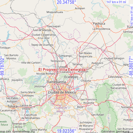
| Map corner | latitude | longitude |
|---|---|---|
| Upper-left | 20.34758°, | -99.78702° |
| Center: | 19.68694°, | -99.08389° |
| Lower-right: | 19.02356°, | -98.38077° |
| Map W x H: | 147.2×147.2 km | = 91.5×91.5mi |
| max Lat: | 32.7° ⇑50% North |
| El Progreso (Villa Esmeralda): | 19.68694° |
| min Lat: | ⇓50% South 14.53588° |
| min Long | El Progreso (Vi | max Long |
| -117.105° | -99.08389° | -86.73105° |
| W 49.1%⇐ | ⇒50.9% E |
Elevation
Elevation of El Progreso (Villa Esmeralda) is 2245 m = 7365 ft, and this is 991.3 m = 3252 ft above average elevation for this country.
| Max E: |
3497 m = 11473 ft | 15.8% |
| El Progreso (Villa Esmeralda) | 2245 m 7365 ft | |
| Avg. | 1253.7 m = 4113 ft | |
Min E: |
-1 m = -3 ft | 84.2% |
See also: Mexico elevation on elevation.city.
Geographical zone
El Progreso (Villa Esmeralda) is located in North Torrid zone (between Equator and Tropic of Cancer). Distance of this Northern Tropic circle is 416.9 km =259 mi to North.| Distance of | km | miles | from El Progreso (Villa Esmeralda) |
|---|---|---|---|
| North Pole | 7818.1 | 4857.9 | to North |
| Arctic Circle | 5212.2 | 3238.7 | to North |
| Tropic Cancer | 416.9 | 259 | to North |
| Equator | 2189 | 1360.2 | to South |


Nearby cities:
15 places around El Progreso (Villa Esmeralda): (largest is in red/bold)
• Alborada Jaltenco
3.2 km =2 mi,  150°
150°
• Colonia 2 de Septiembre
3.8 km =2.4 mi,  293°
293°
• Colonia Pozos y Vías (Fracción Diecisiete A)
2 km =1.2 mi,  22°
22°
• Colonia la Asunción
2.1 km =1.3 mi,  78°
78°
• Colonia los Aguiluchos
4.4 km =2.7 mi,  351°
351°
• Ejido San Pablito (Paraje San Pablito)
4.1 km =2.5 mi,  241°
241°
• Ex-Hacienda Santa Inés
2.5 km =1.6 mi,  28°
28°
• Lomas de Tenopalco
3.4 km =2.1 mi,  299°
299°
• Paraje Trigo Tenco
3.9 km =2.4 mi,  250°
250°
• Prados San Francisco
3.8 km =2.4 mi,  0°
0°
• San Antonio Xahuento
2.5 km =1.6 mi,  282°
282°
• San Francisco Tenopalco
4.4 km =2.7 mi,  310°
310°
• San Pablo de las Salinas
2.5 km =1.6 mi,  206°
206°
• Tonanitla
3.2 km =2 mi,  88°
88°
• Tultepec
4.6 km =2.9 mi,  267°
267°
Sources, notices
• [Note1] Compared only with cities in Mexico existing in our database
• [Src1] Map data: © OpenStreetMap contributors (CC-BY-SA)
• [Src2] Other city data from geonames.org with taken over terms of usage.
• [Src3] Geographical zone / Annual Mean Temperature by Robert A. Rohde @ Wikipedia
