Ejido el Castillo geodata
Ejido el Castillo (State of Mexico) is a populated place; located in Mexico in America/Mexico_City (GMT-6) time zone. With population of 1,062 people, there are 8219 cities with bigger population in this country. Compared to other cities in Mexico, 55.3% of cities are located further ↑North; 54.3% of cities are located further →East and 93.4% of cities have lower elevation than Ejido el Castillo. Note1


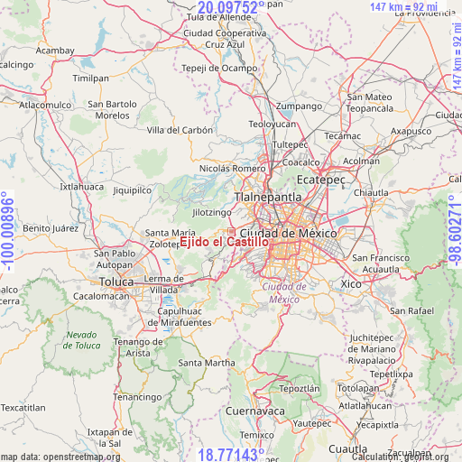
Ejido el Castillo GPS coordinates[2]
19° 26' 8.988" North, 99° 18' 20.988" West
| Map corner | latitude | longitude |
|---|---|---|
| Upper-left | 20.09752°, | -100.00896° |
| Center: | 19.43583°, | -99.30583° |
| Lower-right: | 18.77143°, | -98.60271° |
| Map W x H: | 147.4×147.4 km | = 91.6×91.6mi |
| max Lat: | 32.7° ⇑55.3% North |
| Ejido el Castillo: | 19.43583° |
| min Lat: | ⇓44.7% South 14.53588° |
| min Long | Ejido el Castil | max Long |
| -117.105° | -99.30583° | -86.73105° |
| W 45.7%⇐ | ⇒54.3% E |
Elevation
Elevation of Ejido el Castillo is 2548 m = 8360 ft, and this is 1294.3 m = 4246 ft above average elevation for this country.
| Max E: |
3497 m = 11473 ft | 6.6% |
| Ejido el Castillo | 2548 m 8360 ft | |
| Avg. | 1253.7 m = 4113 ft | |
Min E: |
-1 m = -3 ft | 93.4% |
See also: Mexico elevation on elevation.city.
Geographical zone
Ejido el Castillo is located in North Torrid zone (between Equator and Tropic of Cancer). Distance of this Northern Tropic circle is 444.9 km =276.4 mi to North.| Distance of | km | miles | from Ejido el Castillo |
|---|---|---|---|
| North Pole | 7846 | 4875.3 | to North |
| Arctic Circle | 5240.1 | 3256 | to North |
| Tropic Cancer | 444.9 | 276.4 | to North |
| Equator | 2161.1 | 1342.8 | to South |


Nearby cities:
15 places around Ejido el Castillo: (largest is in red/bold)
• Ampliación el Tejocote
5.7 km =3.5 mi,  16°
16°
• Arenal
2.6 km =1.6 mi,  169°
169°
• Barrio San Miguel Dorami
4.1 km =2.5 mi,  286°
286°
• Barrio la Manzana (La Rinconada)
3.5 km =2.2 mi,  250°
250°
• Barrio las Salinas
4 km =2.5 mi,  273°
273°
• Chimalpa Viejo
4.3 km =2.7 mi, 290°
• El Hielo
5.3 km =3.3 mi,  257°
257°
• La Magdalena Chichicaspa
3.3 km =2.1 mi,  218°
218°
• Llano de las Flores (Barrio del Hueso)
1.7 km =1.1 mi, 270°
• Paraje Trejo (El Chaparral)
3.4 km =2.1 mi,  191°
191°
• Paraje el Mirador
4.6 km =2.9 mi,  208°
208°
• San Bartolomé Coatepec
4.3 km =2.7 mi, 188°
• San Francisco Chimalpa
4.1 km =2.5 mi,  280°
280°
• San José Tejamanil
5.6 km =3.5 mi, 264°
• Santiago Yancuitlalpan
5.8 km =3.6 mi,  178°
178°
Sources, notices
• [Note1] Compared only with cities in Mexico existing in our database
• [Src1] Map data: © OpenStreetMap contributors (CC-BY-SA)
• [Src2] Other city data from geonames.org with taken over terms of usage.
• [Src3] Geographical zone / Annual Mean Temperature by Robert A. Rohde @ Wikipedia
