San Lorenzo geodata
San Lorenzo (Guerrero) is a populated place; located in Mexico in America/Mexico_City (GMT-6) time zone. With population of 1,089 people, there are 7989 cities with bigger population in this country. Compared to other cities in Mexico, 75.3% of cities are located further ↑North; 70.4% of cities are located further →East and 74% of cities have higher elevation than San Lorenzo. Note1


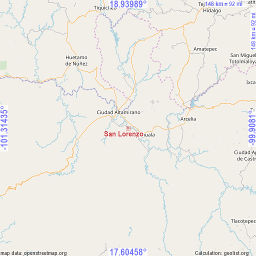
San Lorenzo GPS coordinates[2]
18° 16' 24.672" North, 100° 36' 40.392" West
| Map corner | latitude | longitude |
|---|---|---|
| Upper-left | 18.93989°, | -101.31435° |
| Center: | 18.27352°, | -100.61122° |
| Lower-right: | 17.60458°, | -99.9081° |
| Map W x H: | 148.5×148.5 km | = 92.3×92.3mi |
| max Lat: | 32.7° ⇑75.3% North |
| San Lorenzo: | 18.27352° |
| min Lat: | ⇓24.7% South 14.53588° |
| min Long | San Lorenzo | max Long |
| -117.105° | -100.61122° | -86.73105° |
| W 29.6%⇐ | ⇒70.4% E |
Elevation
Elevation of San Lorenzo is 257 m = 843 ft, and this is 996.7 m = 3270 ft below average elevation for this country.
| Max E: |
3497 m = 11473 ft | 74% |
| Avg. | 1253.7 m = 4113 ft | |
| San Lorenzo | 257 m = 843 ft | |
Min E: |
-1 m = -3 ft | 26% |
See also: Mexico elevation on elevation.city.
Geographical zone
San Lorenzo is located in North Torrid zone (between Equator and Tropic of Cancer). Distance of this Northern Tropic circle is 574.1 km =356.7 mi to North.| Distance of | km | miles | from San Lorenzo |
|---|---|---|---|
| North Pole | 7975.2 | 4955.6 | to North |
| Arctic Circle | 5369.3 | 3336.3 | to North |
| Tropic Cancer | 574.1 | 356.7 | to North |
| Equator | 2031.8 | 1262.5 | to South |


Nearby cities:
15 places around San Lorenzo: (largest is in red/bold)
• Amuco de la Reforma
3.7 km =2.3 mi,  306°
306°
• Chacamerito
5.9 km =3.7 mi,  24°
24°
• Changata
2.7 km =1.7 mi,  91°
91°
• Corral Falso
6.3 km =3.9 mi,  120°
120°
• La Bajada
8.2 km =5.1 mi, 308°
• Las Anonitas
8.4 km =5.2 mi,  153°
153°
• Morelita
5 km =3.1 mi, 94°
• Querendas
8.1 km =5 mi,  342°
342°
• San Juan Chámacua
7.4 km =4.6 mi,  265°
265°
• San Juan de la Cruz
6.2 km =3.9 mi,  262°
262°
• Santa Bárbara
7.1 km =4.4 mi,  334°
334°
• Sinahua
1.4 km =0.9 mi,  53°
53°
• Tanganhuato
1.4 km =0.9 mi,  357°
357°
• Tiringueo
5.7 km =3.5 mi,  95°
95°
• Tlapehuala
8.5 km =5.3 mi, 115°
Sources, notices
• [Note1] Compared only with cities in Mexico existing in our database
• [Src1] Map data: © OpenStreetMap contributors (CC-BY-SA)
• [Src2] Other city data from geonames.org with taken over terms of usage.
• [Src3] Geographical zone / Annual Mean Temperature by Robert A. Rohde @ Wikipedia
