El Mango geodata
El Mango (Michoacán) is a populated place; located in Mexico in America/Mexico_City (GMT-6) time zone. With population of 671 people, there are 12936 cities with bigger population in this country. Compared to other cities in Mexico, 54.6% of cities are located further ↑North; 69% of cities are located further →East and 66.9% of cities have lower elevation than El Mango. Note1


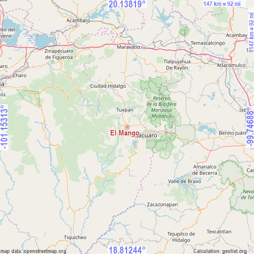
El Mango GPS coordinates[2]
19° 28' 36.012" North, 100° 27' 0" West
| Map corner | latitude | longitude |
|---|---|---|
| Upper-left | 20.13819°, | -101.15313° |
| Center: | 19.47667°, | -100.45° |
| Lower-right: | 18.81244°, | -99.74688° |
| Map W x H: | 147.4×147.4 km | = 91.6×91.6mi |
| max Lat: | 32.7° ⇑54.6% North |
| El Mango: | 19.47667° |
| min Lat: | ⇓45.4% South 14.53588° |
| min Long | El Mango | max Long |
| -117.105° | -100.45° | -86.73105° |
| W 31%⇐ | ⇒69% E |
Elevation
Elevation of El Mango is 1868 m = 6129 ft, and this is 614.3 m = 2015 ft above average elevation for this country.
| Max E: |
3497 m = 11473 ft | 33.1% |
| El Mango | 1868 m 6129 ft | |
| Avg. | 1253.7 m = 4113 ft | |
Min E: |
-1 m = -3 ft | 66.9% |
See also: Mexico elevation on elevation.city.
Geographical zone
El Mango is located in North Torrid zone (between Equator and Tropic of Cancer). Distance of this Northern Tropic circle is 440.3 km =273.6 mi to North.| Distance of | km | miles | from El Mango |
|---|---|---|---|
| North Pole | 7841.5 | 4872.5 | to North |
| Arctic Circle | 5235.6 | 3253.3 | to North |
| Tropic Cancer | 440.3 | 273.6 | to North |
| Equator | 2165.6 | 1345.6 | to South |


Nearby cities:
15 places around El Mango: (largest is in red/bold)
• Agua Salada
2.3 km =1.4 mi,  160°
160°
• Cerrito del Muerto
2.2 km =1.4 mi,  302°
302°
• Colonia Puerto del Obispo
6.7 km =4.2 mi,  346°
346°
• Jungapeo de Juárez
5.1 km =3.2 mi,  247°
247°
• La Garita
3.9 km =2.4 mi,  271°
271°
• La Presa (Segunda Manzana Barrio de Santa Cruz)
7.3 km =4.5 mi,  37°
37°
• La Soledad
6.1 km =3.8 mi,  324°
324°
• La Tinaja
3.9 km =2.4 mi, 267°
• Las Anonas
5.9 km =3.7 mi,  279°
279°
• Lázaro Cárdenas
4 km =2.5 mi,  291°
291°
• Mesa de los Alzati (Mesa de San Felipe)
6.8 km =4.2 mi,  68°
68°
• Ocurio
2.9 km =1.8 mi,  76°
76°
• Puentecillas (Tercera Manzana de Zirahuato)
5.7 km =3.5 mi,  56°
56°
• Puerto Azul (Quinta Manzana de San Felipe)
5.5 km =3.4 mi,  86°
86°
• Zirahuato de los Bernal
6.7 km =4.2 mi, 42°
Sources, notices
• [Note1] Compared only with cities in Mexico existing in our database
• [Src1] Map data: © OpenStreetMap contributors (CC-BY-SA)
• [Src2] Other city data from geonames.org with taken over terms of usage.
• [Src3] Geographical zone / Annual Mean Temperature by Robert A. Rohde @ Wikipedia
