Miguel Hidalgo (Cueritos) geodata
Miguel Hidalgo (Cueritos) (Guanajuato) is a populated place; located in Mexico in America/Mexico_City (GMT-6) time zone. With population of 667 people, there are 13011 cities with bigger population in this country. Compared to other cities in Mexico, 82.4% of cities are located further ↓South; 75.5% of cities are located further →East and 86.8% of cities have lower elevation than Miguel Hidalgo (Cueritos). Note1
Current local time in Miguel Hidalgo (Cueritos):
11:17 AM, MondayDifference from your time zone: hours


Miguel Hidalgo (Cueritos) GPS coordinates[2]
21° 41' 58.992" North, 101° 16' 46.992" West
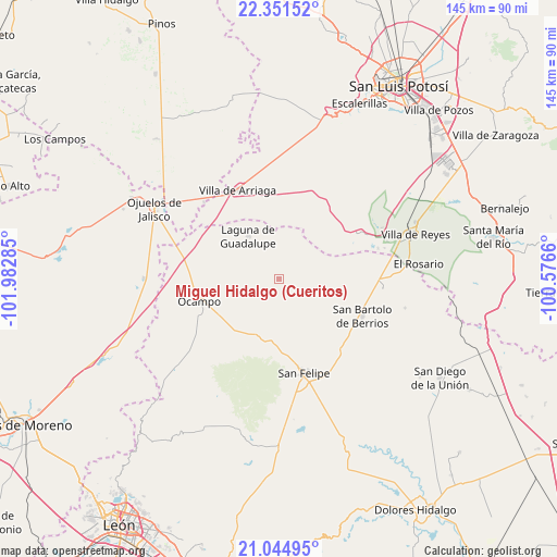
| Map corner | latitude | longitude |
|---|---|---|
| Upper-left | 22.35152°, | -101.98285° |
| Center: | 21.69972°, | -101.27972° |
| Lower-right: | 21.04495°, | -100.5766° |
| Map W x H: | 145.3×145.3 km | = 90.3×90.3mi |
| max Lat: | 32.7° ⇑17.6% North |
| Miguel Hidalgo (Cueritos): | 21.69972° |
| min Lat: | ⇓82.4% South 14.53588° |
| min Long | Miguel Hidalgo | max Long |
| -117.105° | -101.27972° | -86.73105° |
| W 24.5%⇐ | ⇒75.5% E |
Elevation
Elevation of Miguel Hidalgo (Cueritos) is 2305 m = 7562 ft, and this is 1051.3 m = 3449 ft above average elevation for this country.
| Max E: |
3497 m = 11473 ft | 13.2% |
| Miguel Hidalgo (Cueritos) | 2305 m 7562 ft | |
| Avg. | 1253.7 m = 4113 ft | |
Min E: |
-1 m = -3 ft | 86.8% |
See also: Mexico elevation on elevation.city.
Geographical zone
Miguel Hidalgo (Cueritos) is located in North Torrid zone (between Equator and Tropic of Cancer). Distance of this Northern Tropic circle is 193.1 km =120 mi to North.| Distance of | km | miles | from Miguel Hidalgo (Cueritos) |
|---|---|---|---|
| North Pole | 7594.3 | 4718.9 | to North |
| Arctic Circle | 4988.4 | 3099.6 | to North |
| Tropic Cancer | 193.1 | 120 | to North |
| Equator | 2412.8 | 1499.2 | to South |


Nearby cities:
15 places around Miguel Hidalgo (Cueritos): (largest is in red/bold)
• Colonia la Laborcilla
21 km =13 mi,  346°
346°
• El Huizache
18.1 km =11.2 mi,  134°
134°
• El Potrero
15.3 km =9.5 mi,  239°
239°
• Estancia de San Francisco
22.5 km =14 mi,  99°
99°
• Fraccionamiento San Antonio
19.9 km =12.4 mi,  255°
255°
• Fuerte Viejo
15.5 km =9.6 mi,  203°
203°
• La Haciendita
17.8 km =11.1 mi, 239°
• La Sauceda de la Luz
13.3 km =8.3 mi,  136°
136°
• La Tinaja
22.1 km =13.7 mi, 242°
• Laguna de Guadalupe
13.7 km =8.5 mi,  324°
324°
• Las Trojes
20.8 km =12.9 mi,  219°
219°
• Molino de San José
14.4 km =8.9 mi,  173°
173°
• Ocampo
21.5 km =13.4 mi,  254°
254°
• Providencia de Guadalupe (Estancia)
18.4 km =11.4 mi,  313°
313°
• Santa Bárbara
20.7 km =12.9 mi,  209°
209°
Sources, notices
• [Note1] Compared only with cities in Mexico existing in our database
• [Src1] Map data: © OpenStreetMap contributors (CC-BY-SA)
• [Src2] Other city data from geonames.org with taken over terms of usage.
• [Src3] Geographical zone / Annual Mean Temperature by Robert A. Rohde @ Wikipedia
