El Potrero geodata
El Potrero (Guanajuato) is a populated place; located in Mexico in America/Mexico_City (GMT-6) time zone. With population of 518 people, there are 16254 cities with bigger population in this country. Compared to other cities in Mexico, 82.1% of cities are located further ↓South; 76.5% of cities are located further →East and 82.2% of cities have lower elevation than El Potrero. Note1


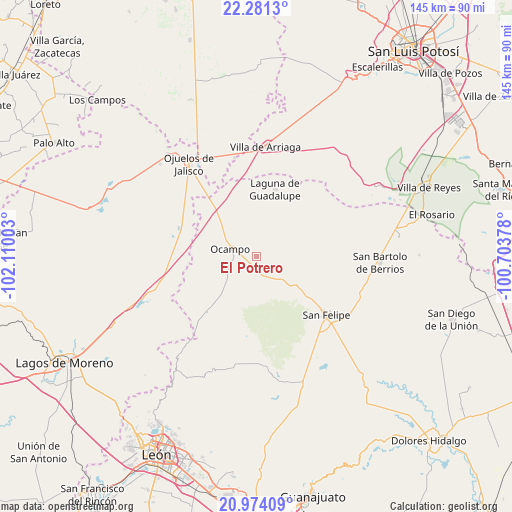
El Potrero GPS coordinates[2]
21° 37' 45.012" North, 101° 24' 24.84" West
| Map corner | latitude | longitude |
|---|---|---|
| Upper-left | 22.2813°, | -102.11003° |
| Center: | 21.62917°, | -101.4069° |
| Lower-right: | 20.97409°, | -100.70378° |
| Map W x H: | 145.3×145.4 km | = 90.3×90.3mi |
| max Lat: | 32.7° ⇑17.9% North |
| El Potrero: | 21.62917° |
| min Lat: | ⇓82.1% South 14.53588° |
| min Long | El Potrero | max Long |
| -117.105° | -101.4069° | -86.73105° |
| W 23.5%⇐ | ⇒76.5% E |
Elevation
Elevation of El Potrero is 2193 m = 7195 ft, and this is 939.3 m = 3082 ft above average elevation for this country.
| Max E: |
3497 m = 11473 ft | 17.8% |
| El Potrero | 2193 m 7195 ft | |
| Avg. | 1253.7 m = 4113 ft | |
Min E: |
-1 m = -3 ft | 82.2% |
See also: Mexico elevation on elevation.city.
Geographical zone
El Potrero is located in North Torrid zone (between Equator and Tropic of Cancer). Distance of this Northern Tropic circle is 201 km =124.9 mi to North.| Distance of | km | miles | from El Potrero |
|---|---|---|---|
| North Pole | 7602.1 | 4723.7 | to North |
| Arctic Circle | 4996.2 | 3104.5 | to North |
| Tropic Cancer | 201 | 124.9 | to North |
| Equator | 2404.9 | 1494.3 | to South |


Nearby cities:
15 places around El Potrero: (largest is in red/bold)
• Fraccionamiento San Antonio
6.9 km =4.3 mi,  296°
296°
• Fuerte Viejo
9.4 km =5.8 mi,  132°
132°
• Gachupines
21.9 km =13.6 mi,  312°
312°
• La Escondida
14.7 km =9.1 mi, 296°
• La Haciendita
2.5 km =1.6 mi,  244°
244°
• La Tinaja
6.8 km =4.2 mi,  249°
249°
• Laguna de Guadalupe
19.7 km =12.2 mi,  15°
15°
• Las Trojes
8.2 km =5.1 mi,  180°
180°
• Miguel Hidalgo (Cueritos)
15.3 km =9.5 mi,  59°
59°
• Molino de San José
16.1 km =10 mi,  113°
113°
• Ocampo
7.8 km =4.8 mi,  284°
284°
• Providencia de Guadalupe (Estancia)
20.5 km =12.7 mi,  359°
359°
• San José del Torreón
18.4 km =11.4 mi,  200°
200°
• San Pedro de Ibarra
21.3 km =13.2 mi,  220°
220°
• Santa Bárbara
10.7 km =6.6 mi,  163°
163°
Sources, notices
• [Note1] Compared only with cities in Mexico existing in our database
• [Src1] Map data: © OpenStreetMap contributors (CC-BY-SA)
• [Src2] Other city data from geonames.org with taken over terms of usage.
• [Src3] Geographical zone / Annual Mean Temperature by Robert A. Rohde @ Wikipedia
