Coamila geodata
Coamila (Hidalgo) is a populated place; located in Mexico in America/Mexico_City (GMT-6) time zone. With population of 637 people, there are 13597 cities with bigger population in this country. Compared to other cities in Mexico, 78% of cities are located further ↓South; 57.3% of cities are located further ←West and 70.7% of cities have higher elevation than Coamila. Note1


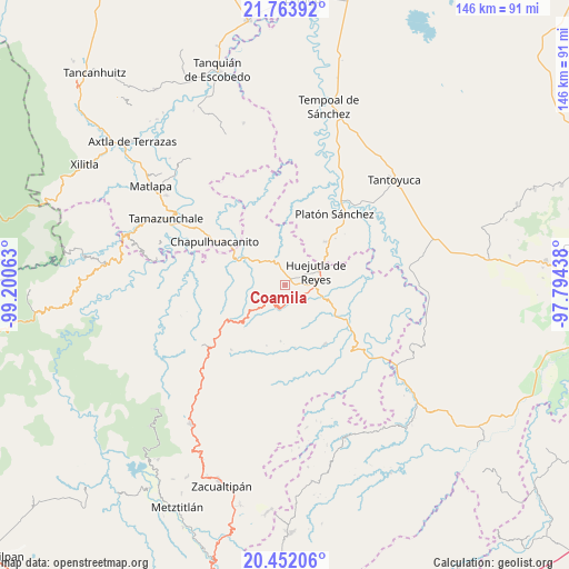
Coamila GPS coordinates[2]
21° 6' 33.984" North, 98° 29' 51" West
| Map corner | latitude | longitude |
|---|---|---|
| Upper-left | 21.76392°, | -99.20063° |
| Center: | 21.10944°, | -98.4975° |
| Lower-right: | 20.45206°, | -97.79438° |
| Map W x H: | 145.9×145.9 km | = 90.7×90.7mi |
| max Lat: | 32.7° ⇑22% North |
| Coamila: | 21.10944° |
| min Lat: | ⇓78% South 14.53588° |
| min Long | Coamila | max Long |
| -117.105° | -98.4975° | -86.73105° |
| W 57.3%⇐ | ⇒42.7% E |
Elevation
Elevation of Coamila is 384 m = 1260 ft, and this is 869.7 m = 2853 ft below average elevation for this country.
| Max E: |
3497 m = 11473 ft | 70.7% |
| Avg. | 1253.7 m = 4113 ft | |
| Coamila | 384 m = 1260 ft | |
Min E: |
-1 m = -3 ft | 29.3% |
See also: Mexico elevation on elevation.city.
Geographical zone
Coamila is located in North Torrid zone (between Equator and Tropic of Cancer). Distance of this Northern Tropic circle is 258.8 km =160.8 mi to North.| Distance of | km | miles | from Coamila |
|---|---|---|---|
| North Pole | 7659.9 | 4759.6 | to North |
| Arctic Circle | 5054 | 3140.4 | to North |
| Tropic Cancer | 258.8 | 160.8 | to North |
| Equator | 2347.1 | 1458.4 | to South |


Nearby cities:
15 places around Coamila: (largest is in red/bold)
• Acoapa
1.7 km =1.1 mi,  39°
39°
• Acuatempa
5.1 km =3.2 mi,  147°
147°
• Aguacatitla
5.1 km =3.2 mi,  85°
85°
• Aquixcuatitla
2.7 km =1.7 mi, 91°
• Contepec
2.9 km =1.8 mi,  13°
13°
• Ixcatlán
5 km =3.1 mi,  230°
230°
• Ixcatépec
2.4 km =1.5 mi,  247°
247°
• Jaltocan
5 km =3.1 mi,  301°
301°
• La Capilla
5.5 km =3.4 mi,  329°
329°
• La Curva Tlaltzintla
5.1 km =3.2 mi,  65°
65°
• Machetla
5.6 km =3.5 mi,  176°
176°
• Macustepetla
2.3 km =1.4 mi,  49°
49°
• Pahuatlán
4.9 km =3 mi, 154°
• Tepexititla
5.8 km =3.6 mi,  64°
64°
• Xocotitla
2.1 km =1.3 mi,  24°
24°
Sources, notices
• [Note1] Compared only with cities in Mexico existing in our database
• [Src1] Map data: © OpenStreetMap contributors (CC-BY-SA)
• [Src2] Other city data from geonames.org with taken over terms of usage.
• [Src3] Geographical zone / Annual Mean Temperature by Robert A. Rohde @ Wikipedia
