Ixcatlán geodata
Ixcatlán (Hidalgo) is a populated place; located in Mexico in America/Mexico_City (GMT-6) time zone. With population of 1,873 people, there are 4639 cities with bigger population in this country. Compared to other cities in Mexico, 77.6% of cities are located further ↓South; 56.8% of cities are located further ←West and 62.3% of cities have higher elevation than Ixcatlán. Note1


Ixcatlán GPS coordinates[2]
21° 4' 52.824" North, 98° 32' 4.848" West
| Map corner | latitude | longitude |
|---|---|---|
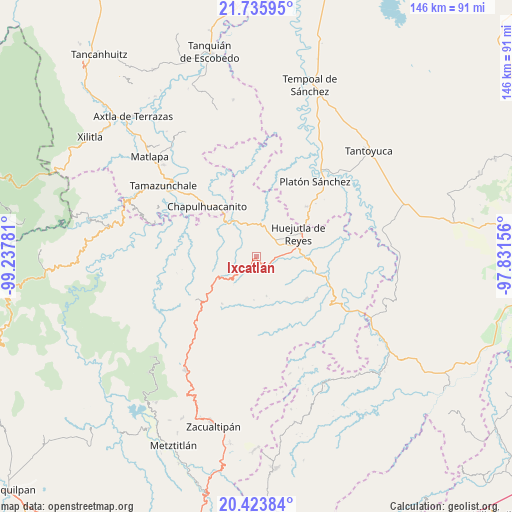
| Upper-left | 21.73595°, | -99.23781° |
| Center: | 21.08134°, | -98.53468° |
| Lower-right: | 20.42384°, | -97.83156° |
| Map W x H: | 145.9×145.9 km | = 90.7×90.7mi |
| max Lat: | 32.7° ⇑22.4% North |
| Ixcatlán: | 21.08134° |
| min Lat: | ⇓77.6% South 14.53588° |
| min Long | Ixcatlán | max Long |
| -117.105° | -98.53468° | -86.73105° |
| W 56.8%⇐ | ⇒43.2% E |
Elevation
Elevation of Ixcatlán is 865 m = 2838 ft, and this is 388.7 m = 1275 ft below average elevation for this country.
| Max E: |
3497 m = 11473 ft | 62.3% |
| Avg. | 1253.7 m = 4113 ft | |
| Ixcatlán | 865 m = 2838 ft | |
Min E: |
-1 m = -3 ft | 37.7% |
See also: Mexico elevation on elevation.city.
Geographical zone
Ixcatlán is located in North Torrid zone (between Equator and Tropic of Cancer). Distance of this Northern Tropic circle is 261.9 km =162.7 mi to North.| Distance of | km | miles | from Ixcatlán |
|---|---|---|---|
| North Pole | 7663 | 4761.6 | to North |
| Arctic Circle | 5057.1 | 3142.3 | to North |
| Tropic Cancer | 261.9 | 162.7 | to North |
| Equator | 2344 | 1456.5 | to South |


Nearby cities:
15 places around Ixcatlán: (largest is in red/bold)
• Acatipa
5.7 km =3.5 mi,  233°
233°
• Acoapa
6.6 km =4.1 mi,  48°
48°
• Acuatempa
6.7 km =4.2 mi,  99°
99°
• Axcaco
1.4 km =0.9 mi,  206°
206°
• Coacuilco
5.9 km =3.7 mi,  294°
294°
• Coamila
5 km =3.1 mi, 50°
• Cuapaxtitla
6 km =3.7 mi,  342°
342°
• Ixcatépec
2.7 km =1.7 mi,  36°
36°
• Jaltocan
5.7 km =3.5 mi,  355°
355°
• Machetla
4.8 km =3 mi,  120°
120°
• Pahuatlán
6.2 km =3.9 mi, 102°
• Peyula
6.1 km =3.8 mi,  220°
220°
• San José
6.3 km =3.9 mi,  257°
257°
• Tehuetlán
4.1 km =2.5 mi,  138°
138°
• Xocotitla
6.9 km =4.3 mi, 43°
Sources, notices
• [Note1] Compared only with cities in Mexico existing in our database
• [Src1] Map data: © OpenStreetMap contributors (CC-BY-SA)
• [Src2] Other city data from geonames.org with taken over terms of usage.
• [Src3] Geographical zone / Annual Mean Temperature by Robert A. Rohde @ Wikipedia
