El Palmar geodata
El Palmar (Tabasco) is a populated place; located in Mexico in America/Mexico_City (GMT-6) time zone. With population of 636 people, there are 13615 cities with bigger population in this country. Compared to other cities in Mexico, 77.5% of cities are located further ↑North; 87.6% of cities are located further ←West and 94% of cities have higher elevation than El Palmar. Note1


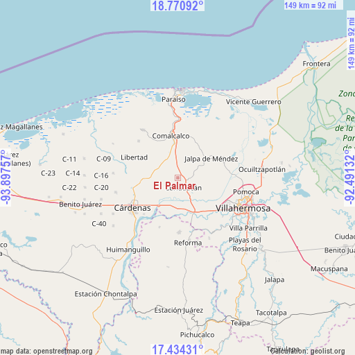
El Palmar GPS coordinates[2]
18° 6' 14.004" North, 93° 11' 39.984" West
| Map corner | latitude | longitude |
|---|---|---|
| Upper-left | 18.77092°, | -93.89757° |
| Center: | 18.10389°, | -93.19444° |
| Lower-right: | 17.43431°, | -92.49132° |
| Map W x H: | 148.6×148.6 km | = 92.3×92.3mi |
| max Lat: | 32.7° ⇑77.5% North |
| El Palmar: | 18.10389° |
| min Lat: | ⇓22.5% South 14.53588° |
| min Long | El Palmar | max Long |
| -117.105° | -93.19444° | -86.73105° |
| W 87.6%⇐ | ⇒12.4% E |
Elevation
Elevation of El Palmar is 15 m = 49 ft, and this is 1238.7 m = 4064 ft below average elevation for this country.
| Max E: |
3497 m = 11473 ft | 94% |
| Avg. | 1253.7 m = 4113 ft | |
| El Palmar | 15 m = 49 ft | |
Min E: |
-1 m = -3 ft | 6% |
See also: Mexico elevation on elevation.city.
Geographical zone
El Palmar is located in North Torrid zone (between Equator and Tropic of Cancer). Distance of this Northern Tropic circle is 593 km =368.5 mi to North.| Distance of | km | miles | from El Palmar |
|---|---|---|---|
| North Pole | 7994.1 | 4967.3 | to North |
| Arctic Circle | 5388.2 | 3348.1 | to North |
| Tropic Cancer | 593 | 368.5 | to North |
| Equator | 2013 | 1250.8 | to South |


Nearby cities:
15 places around El Palmar: (largest is in red/bold)
• Adolfo Ruiz Cortines (Morelitos)
7.6 km =4.7 mi,  162°
162°
• Anta
6.3 km =3.9 mi,  84°
84°
• Boquiapa
8.8 km =5.5 mi,  43°
43°
• Cunduacán
4.8 km =3 mi,  152°
152°
• Cúlico 2da. Sección
7.8 km =4.8 mi,  57°
57°
• Felipe Carrillo Puerto
6.1 km =3.8 mi,  295°
295°
• Huacapa y Amestoy
5.6 km =3.5 mi,  182°
182°
• Huimango 1ra. Sección (El Dren)
4.7 km =2.9 mi,  69°
69°
• Huimango 3ra. Sección (Los Cerros)
3.9 km =2.4 mi,  7°
7°
• Morelos Piedra 3ra. Sección
5.2 km =3.2 mi,  328°
328°
• Oriente 6ta. Sección (Los Mulatos)
8.3 km =5.2 mi, 328°
• Pechucalco
3.2 km =2 mi,  110°
110°
• Pechucalco 2da. Sección (Las Cruces)
2.6 km =1.6 mi, 9°
• San Hipólito
7.8 km =4.8 mi, 77°
• Yoloxóchitl 2da. Sección (San Severo)
7.4 km =4.6 mi,  238°
238°
Sources, notices
• [Note1] Compared only with cities in Mexico existing in our database
• [Src1] Map data: © OpenStreetMap contributors (CC-BY-SA)
• [Src2] Other city data from geonames.org with taken over terms of usage.
• [Src3] Geographical zone / Annual Mean Temperature by Robert A. Rohde @ Wikipedia
