Boquiapa geodata
Boquiapa (Tabasco) is a populated place; located in Mexico in America/Mexico_City (GMT-6) time zone. With population of 1,156 people, there are 7503 cities with bigger population in this country. Compared to other cities in Mexico, 76.7% of cities are located further ↑North; 87.9% of cities are located further ←West and 94% of cities have higher elevation than Boquiapa. Note1


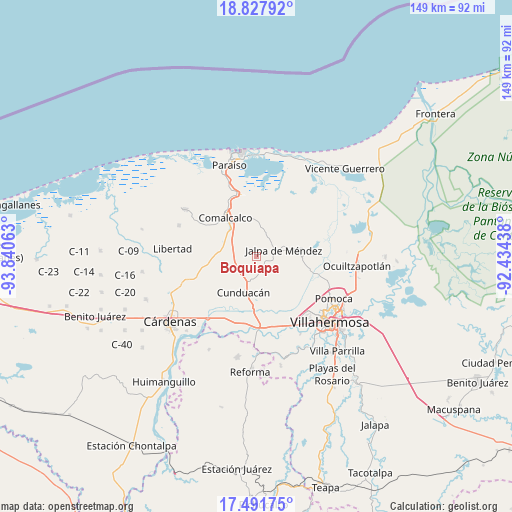
Boquiapa GPS coordinates[2]
18° 9' 39.996" North, 93° 8' 15" West
| Map corner | latitude | longitude |
|---|---|---|
| Upper-left | 18.82792°, | -93.84063° |
| Center: | 18.16111°, | -93.1375° |
| Lower-right: | 17.49175°, | -92.43438° |
| Map W x H: | 148.6×148.6 km | = 92.3×92.3mi |
| max Lat: | 32.7° ⇑76.7% North |
| Boquiapa: | 18.16111° |
| min Lat: | ⇓23.3% South 14.53588° |
| min Long | Boquiapa | max Long |
| -117.105° | -93.1375° | -86.73105° |
| W 87.9%⇐ | ⇒12.1% E |
Elevation
Elevation of Boquiapa is 15 m = 49 ft, and this is 1238.7 m = 4064 ft below average elevation for this country.
| Max E: |
3497 m = 11473 ft | 94% |
| Avg. | 1253.7 m = 4113 ft | |
| Boquiapa | 15 m = 49 ft | |
Min E: |
-1 m = -3 ft | 6% |
See also: Mexico elevation on elevation.city.
Geographical zone
Boquiapa is located in North Torrid zone (between Equator and Tropic of Cancer). Distance of this Northern Tropic circle is 586.6 km =364.5 mi to North.| Distance of | km | miles | from Boquiapa |
|---|---|---|---|
| North Pole | 7987.7 | 4963.3 | to North |
| Arctic Circle | 5381.8 | 3344.1 | to North |
| Tropic Cancer | 586.6 | 364.5 | to North |
| Equator | 2019.3 | 1254.7 | to South |


Nearby cities:
15 places around Boquiapa: (largest is in red/bold)
• Anta
5.8 km =3.6 mi,  177°
177°
• Cúlico 2da. Sección
2.3 km =1.4 mi,  165°
165°
• El Carmen
6.2 km =3.9 mi,  345°
345°
• Gregorio Méndez
5.4 km =3.4 mi,  43°
43°
• Hermenegildo Galeana 2da. Sección
1.1 km =0.7 mi,  13°
13°
• Huapacal 2da. Sección (Punta Brava)
5.4 km =3.4 mi,  317°
317°
• Huimango 1ra. Sección (El Dren)
5 km =3.1 mi,  199°
199°
• Huimango 3ra. Sección (Los Cerros)
6.1 km =3.8 mi,  245°
245°
• Iquinuapa
4.3 km =2.7 mi,  24°
24°
• La Pera
1.8 km =1.1 mi,  79°
79°
• Nicolás Bravo
5.8 km =3.6 mi,  96°
96°
• Pechucalco 2da. Sección (Las Cruces)
6.8 km =4.2 mi,  235°
235°
• Pueblo Viejo
7 km =4.3 mi,  51°
51°
• San Hipólito
4.9 km =3 mi,  161°
161°
• Santa Lucía
6.9 km =4.3 mi,  153°
153°
Sources, notices
• [Note1] Compared only with cities in Mexico existing in our database
• [Src1] Map data: © OpenStreetMap contributors (CC-BY-SA)
• [Src2] Other city data from geonames.org with taken over terms of usage.
• [Src3] Geographical zone / Annual Mean Temperature by Robert A. Rohde @ Wikipedia
