San Vicente Amole geodata
San Vicente Amole (Guerrero) is a populated place; located in Mexico in America/Mexico_City (GMT-6) time zone. With population of 622 people, there are 13890 cities with bigger population in this country. Compared to other cities in Mexico, 84.7% of cities are located further ↑North; 54.9% of cities are located further ←West and 83.5% of cities have lower elevation than San Vicente Amole. Note1


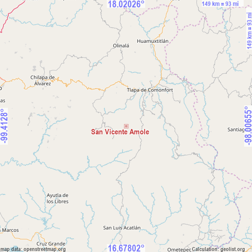
San Vicente Amole GPS coordinates[2]
17° 21' 1.332" North, 98° 42' 34.812" West
| Map corner | latitude | longitude |
|---|---|---|
| Upper-left | 18.02026°, | -99.4128° |
| Center: | 17.35037°, | -98.70967° |
| Lower-right: | 16.67802°, | -98.00655° |
| Map W x H: | 149.2×149.2 km | = 92.7×92.7mi |
| max Lat: | 32.7° ⇑84.7% North |
| San Vicente Amole: | 17.35037° |
| min Lat: | ⇓15.3% South 14.53588° |
| min Long | San Vicente Amo | max Long |
| -117.105° | -98.70967° | -86.73105° |
| W 54.9%⇐ | ⇒45.1% E |
Elevation
Elevation of San Vicente Amole is 2230 m = 7316 ft, and this is 976.3 m = 3203 ft above average elevation for this country.
| Max E: |
3497 m = 11473 ft | 16.5% |
| San Vicente Amole | 2230 m 7316 ft | |
| Avg. | 1253.7 m = 4113 ft | |
Min E: |
-1 m = -3 ft | 83.5% |
See also: Mexico elevation on elevation.city.
Geographical zone
San Vicente Amole is located in North Torrid zone (between Equator and Tropic of Cancer). Distance of this Northern Tropic circle is 676.7 km =420.5 mi to North.| Distance of | km | miles | from San Vicente Amole |
|---|---|---|---|
| North Pole | 8077.9 | 5019.4 | to North |
| Arctic Circle | 5472 | 3400.1 | to North |
| Tropic Cancer | 676.7 | 420.5 | to North |
| Equator | 1929.2 | 1198.7 | to South |


Nearby cities:
15 places around San Vicente Amole: (largest is in red/bold)
• Ahuixotitla
11 km =6.8 mi,  295°
295°
• Colonia la Reforma
8.3 km =5.2 mi,  354°
354°
• El Capulín
11.4 km =7.1 mi,  235°
235°
• El Tejocote
5.9 km =3.7 mi,  113°
113°
• Huiztlatzala
8 km =5 mi,  306°
306°
• Moyotepec (Moyotepec de Juárez)
3.3 km =2.1 mi,  129°
129°
• Ocoapa
5.1 km =3.2 mi,  42°
42°
• Ocotequila
11.5 km =7.1 mi,  17°
17°
• Patlicha
10 km =6.2 mi, 352°
• Potoichán
8.1 km =5 mi, 352°
• Santa Anita
8.4 km =5.2 mi, 353°
• Tepecocatlán
10.3 km =6.4 mi, 106°
• Tlacoapa
10.5 km =6.5 mi,  203°
203°
• Zapotitlán Tablas
11.1 km =6.9 mi,  317°
317°
• Zilacayota
11.7 km =7.3 mi, 242°
Sources, notices
• [Note1] Compared only with cities in Mexico existing in our database
• [Src1] Map data: © OpenStreetMap contributors (CC-BY-SA)
• [Src2] Other city data from geonames.org with taken over terms of usage.
• [Src3] Geographical zone / Annual Mean Temperature by Robert A. Rohde @ Wikipedia
