El Capulín geodata
El Capulín (Guerrero) is a populated place; located in Mexico in America/Mexico_City (GMT-6) time zone. With population of 651 people, there are 13306 cities with bigger population in this country. Compared to other cities in Mexico, 85.4% of cities are located further ↑North; 53.6% of cities are located further ←West and 81.3% of cities have lower elevation than El Capulín. Note1


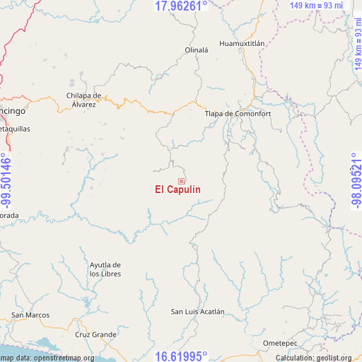
El Capulín GPS coordinates[2]
17° 17' 33" North, 98° 47' 53.988" West
| Map corner | latitude | longitude |
|---|---|---|
| Upper-left | 17.96261°, | -99.50146° |
| Center: | 17.2925°, | -98.79833° |
| Lower-right: | 16.61995°, | -98.09521° |
| Map W x H: | 149.3×149.3 km | = 92.8×92.8mi |
| max Lat: | 32.7° ⇑85.4% North |
| El Capulín: | 17.2925° |
| min Lat: | ⇓14.6% South 14.53588° |
| min Long | El Capulín | max Long |
| -117.105° | -98.79833° | -86.73105° |
| W 53.6%⇐ | ⇒46.4% E |
Elevation
Elevation of El Capulín is 2171 m = 7123 ft, and this is 917.3 m = 3010 ft above average elevation for this country.
| Max E: |
3497 m = 11473 ft | 18.7% |
| El Capulín | 2171 m 7123 ft | |
| Avg. | 1253.7 m = 4113 ft | |
Min E: |
-1 m = -3 ft | 81.3% |
See also: Mexico elevation on elevation.city.
Geographical zone
El Capulín is located in North Torrid zone (between Equator and Tropic of Cancer). Distance of this Northern Tropic circle is 683.2 km =424.5 mi to North.| Distance of | km | miles | from El Capulín |
|---|---|---|---|
| North Pole | 8084.3 | 5023.3 | to North |
| Arctic Circle | 5478.4 | 3404.1 | to North |
| Tropic Cancer | 683.2 | 424.5 | to North |
| Equator | 1922.7 | 1194.7 | to South |


Nearby cities:
15 places around El Capulín: (largest is in red/bold)
• Ahuixotitla
11.1 km =6.9 mi,  357°
357°
• Apetzuca
3.6 km =2.2 mi,  273°
273°
• Barranca Pobre
10.1 km =6.3 mi,  241°
241°
• El Chirimoyo
11.2 km =7 mi,  300°
300°
• El Mirador
11.1 km =6.9 mi,  227°
227°
• El Tejocote
2.3 km =1.4 mi,  200°
200°
• Escalerilla Lagunas
10.8 km =6.7 mi,  331°
331°
• Huiztlatzala
11.6 km =7.2 mi,  15°
15°
• Loma Tuza
10.1 km =6.3 mi,  311°
311°
• San Vicente Amole
11.4 km =7.1 mi,  55°
55°
• Tamaloya
10.2 km =6.3 mi,  344°
344°
• Tenamazapa
9 km =5.6 mi, 198°
• Tlacoapa
6.2 km =3.9 mi,  121°
121°
• Zilacayota
1.4 km =0.9 mi,  318°
318°
• Zontecomapa
5.9 km =3.7 mi, 301°
Sources, notices
• [Note1] Compared only with cities in Mexico existing in our database
• [Src1] Map data: © OpenStreetMap contributors (CC-BY-SA)
• [Src2] Other city data from geonames.org with taken over terms of usage.
• [Src3] Geographical zone / Annual Mean Temperature by Robert A. Rohde @ Wikipedia
