Bomintzá geodata
Bomintzá (Querétaro) is a populated place; located in Mexico in America/Mexico_City (GMT-6) time zone. With population of 596 people, there are 14429 cities with bigger population in this country. Compared to other cities in Mexico, 75.6% of cities are located further ↓South; 64% of cities are located further →East and 72.6% of cities have lower elevation than Bomintzá. Note1


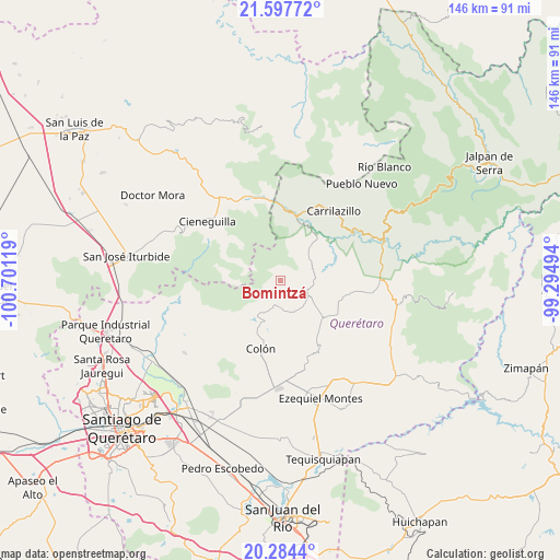
Bomintzá GPS coordinates[2]
20° 56' 33" North, 99° 59' 53.016" West
| Map corner | latitude | longitude |
|---|---|---|
| Upper-left | 21.59772°, | -100.70119° |
| Center: | 20.9425°, | -99.99806° |
| Lower-right: | 20.2844°, | -99.29494° |
| Map W x H: | 146×146 km | = 90.7×90.7mi |
| max Lat: | 32.7° ⇑24.4% North |
| Bomintzá: | 20.9425° |
| min Lat: | ⇓75.6% South 14.53588° |
| min Long | Bomintzá | max Long |
| -117.105° | -99.99806° | -86.73105° |
| W 36%⇐ | ⇒64% E |
Elevation
Elevation of Bomintzá is 1980 m = 6496 ft, and this is 726.3 m = 2383 ft above average elevation for this country.
| Max E: |
3497 m = 11473 ft | 27.4% |
| Bomintzá | 1980 m 6496 ft | |
| Avg. | 1253.7 m = 4113 ft | |
Min E: |
-1 m = -3 ft | 72.6% |
See also: Mexico elevation on elevation.city.
Geographical zone
Bomintzá is located in North Torrid zone (between Equator and Tropic of Cancer). Distance of this Northern Tropic circle is 277.3 km =172.3 mi to North.| Distance of | km | miles | from Bomintzá |
|---|---|---|---|
| North Pole | 7678.5 | 4771.2 | to North |
| Arctic Circle | 5072.6 | 3152 | to North |
| Tropic Cancer | 277.3 | 172.3 | to North |
| Equator | 2328.6 | 1446.9 | to South |


Nearby cities:
15 places around Bomintzá: (largest is in red/bold)
• Barrio de Casas Viejas
8.7 km =5.4 mi,  110°
110°
• Barrio de García
8.7 km =5.4 mi,  159°
159°
• Casa Blanca
3.3 km =2.1 mi, 111°
• Diezmeros
8.9 km =5.5 mi,  147°
147°
• El Cerrito Parado
4.3 km =2.7 mi,  117°
117°
• El Poleo
10 km =6.2 mi,  212°
212°
• Gudiños
7 km =4.3 mi,  197°
197°
• Horno de Cal
9.5 km =5.9 mi, 120°
• Los González
3 km =1.9 mi,  102°
102°
• Mesa de Ramírez
1.7 km =1.1 mi, 152°
• Panales
7.4 km =4.6 mi,  178°
178°
• Sabino de San Ambrosio
3.9 km =2.4 mi,  132°
132°
• San Miguel
9.1 km =5.7 mi, 155°
• San Pablo Tolimán
13.9 km =8.6 mi, 132°
• Tolimán
8 km =5 mi, 118°
Sources, notices
• [Note1] Compared only with cities in Mexico existing in our database
• [Src1] Map data: © OpenStreetMap contributors (CC-BY-SA)
• [Src2] Other city data from geonames.org with taken over terms of usage.
• [Src3] Geographical zone / Annual Mean Temperature by Robert A. Rohde @ Wikipedia
