Betania geodata
Betania (Quintana Roo) is a populated place; located in Mexico in America/Cancun (GMT-5) time zone. With population of 584 people, there are 14684 cities with bigger population in this country. Compared to other cities in Mexico, 51.1% of cities are located further ↑North; 99.5% of cities are located further ←West and 92.5% of cities have higher elevation than Betania. Note1


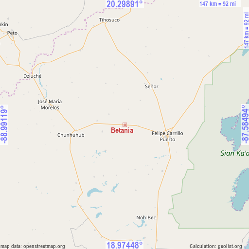
Betania GPS coordinates[2]
19° 38' 17.016" North, 88° 17' 17.016" West
| Map corner | latitude | longitude |
|---|---|---|
| Upper-left | 20.29891°, | -88.99119° |
| Center: | 19.63806°, | -88.28806° |
| Lower-right: | 18.97448°, | -87.58494° |
| Map W x H: | 147.3×147.3 km | = 91.5×91.5mi |
| max Lat: | 32.7° ⇑51.1% North |
| Betania: | 19.63806° |
| min Lat: | ⇓48.9% South 14.53588° |
| min Long | Betania | max Long |
| -117.105° | -88.28806° | -86.73105° |
| W 99.5%⇐ | ⇒0.5% E |
Elevation
Elevation of Betania is 18 m = 59 ft, and this is 1235.7 m = 4054 ft below average elevation for this country.
| Max E: |
3497 m = 11473 ft | 92.5% |
| Avg. | 1253.7 m = 4113 ft | |
| Betania | 18 m = 59 ft | |
Min E: |
-1 m = -3 ft | 7.5% |
See also: Mexico elevation on elevation.city.
Geographical zone
Betania is located in North Torrid zone (between Equator and Tropic of Cancer). Distance of this Northern Tropic circle is 422.4 km =262.5 mi to North.| Distance of | km | miles | from Betania |
|---|---|---|---|
| North Pole | 7823.5 | 4861.3 | to North |
| Arctic Circle | 5217.6 | 3242.1 | to North |
| Tropic Cancer | 422.4 | 262.5 | to North |
| Equator | 2183.5 | 1356.8 | to South |


Nearby cities:
15 places around Betania: (largest is in red/bold)
• Chan Santa Cruz
30.4 km =18.9 mi,  188°
188°
• Chunhuhub
32.4 km =20.1 mi,  259°
259°
• Chunhuás
8.2 km =5.1 mi,  95°
95°
• Dzula
13.9 km =8.6 mi,  253°
253°
• Felipe Carrillo Puerto
26.3 km =16.3 mi, 104°
• Filomeno Mata
27 km =16.8 mi,  335°
335°
• Laguna Kaná
18.9 km =11.7 mi,  217°
217°
• Polyuc
28.8 km =17.9 mi, 263°
• Santa María Poniente
32.6 km =20.3 mi,  202°
202°
• Señor
28 km =17.4 mi,  34°
34°
• Tixcacal Guardia
27.3 km =17 mi, 25°
• Tuzik
33.6 km =20.9 mi,  23°
23°
• X-pichil
11.3 km =7 mi,  304°
304°
• X-yatil
16.5 km =10.3 mi,  279°
279°
• Yaxley
17.2 km =10.7 mi, 32°
Sources, notices
• [Note1] Compared only with cities in Mexico existing in our database
• [Src1] Map data: © OpenStreetMap contributors (CC-BY-SA)
• [Src2] Other city data from geonames.org with taken over terms of usage.
• [Src3] Geographical zone / Annual Mean Temperature by Robert A. Rohde @ Wikipedia
