Tixcacal Guardia geodata
Tixcacal Guardia (Quintana Roo) is a populated place; located in Mexico in America/Cancun (GMT-5) time zone. With population of 659 people, there are 13168 cities with bigger population in this country. Compared to other cities in Mexico, 54.2% of cities are located further ↓South; 99.6% of cities are located further ←West and 91.6% of cities have higher elevation than Tixcacal Guardia. Note1


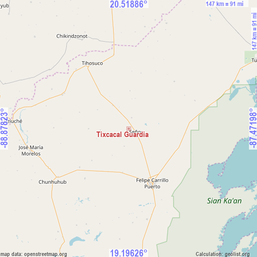
Tixcacal Guardia GPS coordinates[2]
19° 51' 32.184" North, 88° 10' 30.36" West
| Map corner | latitude | longitude |
|---|---|---|
| Upper-left | 20.51886°, | -88.87823° |
| Center: | 19.85894°, | -88.1751° |
| Lower-right: | 19.19626°, | -87.47198° |
| Map W x H: | 147.1×147.1 km | = 91.4×91.4mi |
| max Lat: | 32.7° ⇑45.8% North |
| Tixcacal Guardia: | 19.85894° |
| min Lat: | ⇓54.2% South 14.53588° |
| min Long | Tixcacal Guardi | max Long |
| -117.105° | -88.1751° | -86.73105° |
| W 99.6%⇐ | ⇒0.40000000000001% E |
Elevation
Elevation of Tixcacal Guardia is 20 m = 66 ft, and this is 1233.7 m = 4048 ft below average elevation for this country.
| Max E: |
3497 m = 11473 ft | 91.6% |
| Avg. | 1253.7 m = 4113 ft | |
| Tixcacal Guardia | 20 m = 66 ft | |
Min E: |
-1 m = -3 ft | 8.4% |
See also: Mexico elevation on elevation.city.
Geographical zone
Tixcacal Guardia is located in North Torrid zone (between Equator and Tropic of Cancer). Distance of this Northern Tropic circle is 397.8 km =247.2 mi to North.| Distance of | km | miles | from Tixcacal Guardia |
|---|---|---|---|
| North Pole | 7799 | 4846.1 | to North |
| Arctic Circle | 5193.1 | 3226.8 | to North |
| Tropic Cancer | 397.8 | 247.2 | to North |
| Equator | 2208.1 | 1372 | to South |


Nearby cities:
15 places around Tixcacal Guardia: (largest is in red/bold)
• Betania
27.3 km =17 mi,  205°
205°
• Chumpón
41.1 km =25.5 mi,  67°
67°
• Chun-Yah
37.5 km =23.3 mi,  43°
43°
• Chunhuás
25.7 km =16 mi,  188°
188°
• Dzula
38 km =23.6 mi,  221°
221°
• Felipe Carrillo Puerto
34.1 km =21.2 mi,  156°
156°
• Filomeno Mata
23 km =14.3 mi,  270°
270°
• Huay Max
41.9 km =26 mi,  299°
299°
• Saban
42.7 km =26.5 mi, 297°
• Santa Rosa Segundo
16.1 km =10 mi,  325°
325°
• Señor
4.5 km =2.8 mi,  111°
111°
• Tuzik
6.5 km =4 mi,  14°
14°
• X-pichil
27.9 km =17.3 mi,  229°
229°
• X-yatil
35.7 km =22.2 mi, 232°
• Yaxley
10.4 km =6.5 mi, 194°
Sources, notices
• [Note1] Compared only with cities in Mexico existing in our database
• [Src1] Map data: © OpenStreetMap contributors (CC-BY-SA)
• [Src2] Other city data from geonames.org with taken over terms of usage.
• [Src3] Geographical zone / Annual Mean Temperature by Robert A. Rohde @ Wikipedia
