Felipe Carrillo Puerto geodata
Felipe Carrillo Puerto (Quintana Roo) is a seat of a second-order administrative division; located in Mexico in America/Cancun (GMT-5) time zone. With population of 25,744 people, there are 392 cities with bigger population in this country. Compared to other cities in Mexico, 52.5% of cities are located further ↑North; 99.7% of cities are located further ←West and 94% of cities have higher elevation than Felipe Carrillo Puerto. Note1
Current local time in Felipe Carrillo Puerto:
06:34 AM, WednesdayDifference from your time zone: hours


Felipe Carrillo Puerto GPS coordinates[2]
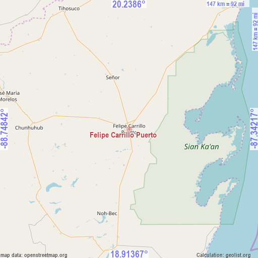
19° 34' 39" North, 88° 2' 43.044" West
| Map corner | latitude | longitude |
|---|---|---|
| Upper-left | 20.2386°, | -88.74842° |
| Center: | 19.5775°, | -88.04529° |
| Lower-right: | 18.91367°, | -87.34217° |
| Map W x H: | 147.3×147.3 km | = 91.5×91.5mi |
| max Lat: | 32.7° ⇑52.5% North |
| Felipe Carrillo Puerto: | 19.5775° |
| min Lat: | ⇓47.5% South 14.53588° |
| min Long | Felipe Carrillo | max Long |
| -117.105° | -88.04529° | -86.73105° |
| W 99.7%⇐ | ⇒0.3% E |
Elevation
Elevation of Felipe Carrillo Puerto is 15 m = 49 ft, and this is 1238.7 m = 4064 ft below average elevation for this country.
| Max E: |
3497 m = 11473 ft | 94% |
| Avg. | 1253.7 m = 4113 ft | |
| Felipe Carrillo Puerto | 15 m = 49 ft | |
Min E: |
-1 m = -3 ft | 6% |
See also: Mexico elevation on elevation.city.
Geographical zone
Felipe Carrillo Puerto is located in North Torrid zone (between Equator and Tropic of Cancer). Distance of this Northern Tropic circle is 429.1 km =266.6 mi to North.| Distance of | km | miles | from Felipe Carrillo Puerto |
|---|---|---|---|
| North Pole | 7830.2 | 4865.5 | to North |
| Arctic Circle | 5224.4 | 3246.3 | to North |
| Tropic Cancer | 429.1 | 266.6 | to North |
| Equator | 2176.8 | 1352.6 | to South |


Nearby cities:
15 places around Felipe Carrillo Puerto: (largest is in red/bold)
• Betania
26.3 km =16.3 mi,  284°
284°
• Chan Santa Cruz
38 km =23.6 mi,  232°
232°
• Chunhuás
18.3 km =11.4 mi,  288°
288°
• Dzula
38.9 km =24.2 mi,  274°
274°
• Filomeno Mata
48.2 km =30 mi,  310°
310°
• Laguna Kaná
37.8 km =23.5 mi,  257°
257°
• Naranjal Poniente
49.7 km =30.9 mi,  241°
241°
• Santa María Poniente
44.5 km =27.7 mi, 238°
• Señor
31.1 km =19.3 mi,  342°
342°
• Tixcacal Guardia
34.1 km =21.2 mi, 336°
• Tuzik
39.4 km =24.5 mi, 342°
• X-Hazil Sur
20.9 km =13 mi,  188°
188°
• X-pichil
37.1 km =23.1 mi, 290°
• X-yatil
42.8 km =26.6 mi, 282°
• Yaxley
26.7 km =16.6 mi,  322°
322°
Sources, notices
• [Note1] Compared only with cities in Mexico existing in our database
• [Src1] Map data: © OpenStreetMap contributors (CC-BY-SA)
• [Src2] Other city data from geonames.org with taken over terms of usage.
• [Src3] Geographical zone / Annual Mean Temperature by Robert A. Rohde @ Wikipedia
