Milpillas geodata
Milpillas (San Luis Potosí) is a populated place; located in Mexico in America/Mexico_City (GMT-6) time zone. With population of 580 people, there are 14779 cities with bigger population in this country. Compared to other cities in Mexico, 85.5% of cities are located further ↓South; 74.5% of cities are located further →East and 75.9% of cities have lower elevation than Milpillas. Note1


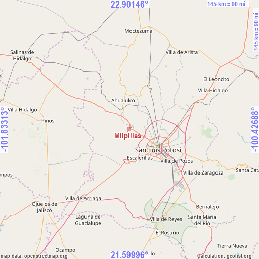
Milpillas GPS coordinates[2]
22° 15' 7.992" North, 101° 7' 48" West
| Map corner | latitude | longitude |
|---|---|---|
| Upper-left | 22.90146°, | -101.83313° |
| Center: | 22.25222°, | -101.13° |
| Lower-right: | 21.59996°, | -100.42688° |
| Map W x H: | 144.7×144.7 km | = 89.9×89.9mi |
| max Lat: | 32.7° ⇑14.5% North |
| Milpillas: | 22.25222° |
| min Lat: | ⇓85.5% South 14.53588° |
| min Long | Milpillas | max Long |
| -117.105° | -101.13° | -86.73105° |
| W 25.5%⇐ | ⇒74.5% E |
Elevation
Elevation of Milpillas is 2046 m = 6713 ft, and this is 792.3 m = 2599 ft above average elevation for this country.
| Max E: |
3497 m = 11473 ft | 24.1% |
| Milpillas | 2046 m 6713 ft | |
| Avg. | 1253.7 m = 4113 ft | |
Min E: |
-1 m = -3 ft | 75.9% |
See also: Mexico elevation on elevation.city.
Geographical zone
Milpillas is located in North Torrid zone (between Equator and Tropic of Cancer). Distance of this Northern Tropic circle is 131.7 km =81.8 mi to North.| Distance of | km | miles | from Milpillas |
|---|---|---|---|
| North Pole | 7532.8 | 4680.7 | to North |
| Arctic Circle | 4927 | 3061.5 | to North |
| Tropic Cancer | 131.7 | 81.8 | to North |
| Equator | 2474.2 | 1537.4 | to South |


Nearby cities:
15 places around Milpillas: (largest is in red/bold)
• Agua Señora
9.2 km =5.7 mi,  100°
100°
• Cerrito de Jaral
7.6 km =4.7 mi,  114°
114°
• Derramaderos
4.6 km =2.9 mi,  351°
351°
• El Jaralito
10.2 km =6.3 mi,  124°
124°
• La Campana
4.3 km =2.7 mi, 109°
• La Loma
9.2 km =5.7 mi, 117°
• La Tapona
10.2 km =6.3 mi,  253°
253°
• Las Moras
5.3 km =3.3 mi,  73°
73°
• Los Retes
6.8 km =4.2 mi,  92°
92°
• Matancillas
7.9 km =4.9 mi,  77°
77°
• Mexquitic de Carmona
2.4 km =1.5 mi,  48°
48°
• Paso Blanco
8 km =5 mi,  129°
129°
• Rincón de San José
4.8 km =3 mi,  314°
314°
• Rincón del Porvenir
9.2 km =5.7 mi,  328°
328°
• Suspiro Picacho
6.4 km =4 mi,  135°
135°
Sources, notices
• [Note1] Compared only with cities in Mexico existing in our database
• [Src1] Map data: © OpenStreetMap contributors (CC-BY-SA)
• [Src2] Other city data from geonames.org with taken over terms of usage.
• [Src3] Geographical zone / Annual Mean Temperature by Robert A. Rohde @ Wikipedia
