Chacoaco geodata
Chacoaco (Veracruz) is a populated place; located in Mexico in America/Mexico_City (GMT-6) time zone. With population of 562 people, there are 15183 cities with bigger population in this country. Compared to other cities in Mexico, 74.9% of cities are located further ↓South; 70.8% of cities are located further ←West and 93.5% of cities have higher elevation than Chacoaco. Note1


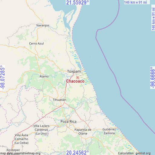
Chacoaco GPS coordinates[2]
20° 54' 14.004" North, 97° 22' 10.992" West
| Map corner | latitude | longitude |
|---|---|---|
| Upper-left | 21.55929°, | -98.07285° |
| Center: | 20.90389°, | -97.36972° |
| Lower-right: | 20.24562°, | -96.6666° |
| Map W x H: | 146.1×146.1 km | = 90.8×90.8mi |
| max Lat: | 32.7° ⇑25.1% North |
| Chacoaco: | 20.90389° |
| min Lat: | ⇓74.9% South 14.53588° |
| min Long | Chacoaco | max Long |
| -117.105° | -97.36972° | -86.73105° |
| W 70.8%⇐ | ⇒29.2% E |
Elevation
Elevation of Chacoaco is 16 m = 52 ft, and this is 1237.7 m = 4061 ft below average elevation for this country.
| Max E: |
3497 m = 11473 ft | 93.5% |
| Avg. | 1253.7 m = 4113 ft | |
| Chacoaco | 16 m = 52 ft | |
Min E: |
-1 m = -3 ft | 6.5% |
See also: Mexico elevation on elevation.city.
Geographical zone
Chacoaco is located in North Torrid zone (between Equator and Tropic of Cancer). Distance of this Northern Tropic circle is 281.6 km =175 mi to North.| Distance of | km | miles | from Chacoaco |
|---|---|---|---|
| North Pole | 7682.8 | 4773.9 | to North |
| Arctic Circle | 5076.9 | 3154.6 | to North |
| Tropic Cancer | 281.6 | 175 | to North |
| Equator | 2324.3 | 1444.3 | to South |


Nearby cities:
15 places around Chacoaco: (largest is in red/bold)
• Aire Libre
11.1 km =6.9 mi,  150°
150°
• Alto Lucero
9.3 km =5.8 mi,  306°
306°
• Banderas
10 km =6.2 mi,  345°
345°
• Ceiba Rica
7.2 km =4.5 mi,  257°
257°
• Cobos
4 km =2.5 mi,  10°
10°
• Colonia México Lindo
10.8 km =6.7 mi,  298°
298°
• Cruz Naranjos
10.7 km =6.6 mi,  316°
316°
• El Salto de la Reforma
12.6 km =7.8 mi,  182°
182°
• La Victoria (La Peñita)
3.7 km =2.3 mi,  355°
355°
• Peña de Afuera
7.7 km =4.8 mi, 177°
• Praxedis Guerrero (Kilómetro 18)
13 km =8.1 mi, 152°
• Santiago de la Peña
5.9 km =3.7 mi, 321°
• Tampamachoco
8.7 km =5.4 mi,  32°
32°
• Tierra Blanca
9.9 km =6.2 mi,  251°
251°
• Túxpam de Rodríguez Cano
7.2 km =4.5 mi,  326°
326°
Sources, notices
• [Note1] Compared only with cities in Mexico existing in our database
• [Src1] Map data: © OpenStreetMap contributors (CC-BY-SA)
• [Src2] Other city data from geonames.org with taken over terms of usage.
• [Src3] Geographical zone / Annual Mean Temperature by Robert A. Rohde @ Wikipedia
