Aire Libre geodata
Aire Libre (Veracruz) is a populated place; located in Mexico in America/Mexico_City (GMT-6) time zone. With population of 688 people, there are 12631 cities with bigger population in this country. Compared to other cities in Mexico, 73.5% of cities are located further ↓South; 71.4% of cities are located further ←West and 97% of cities have higher elevation than Aire Libre. Note1


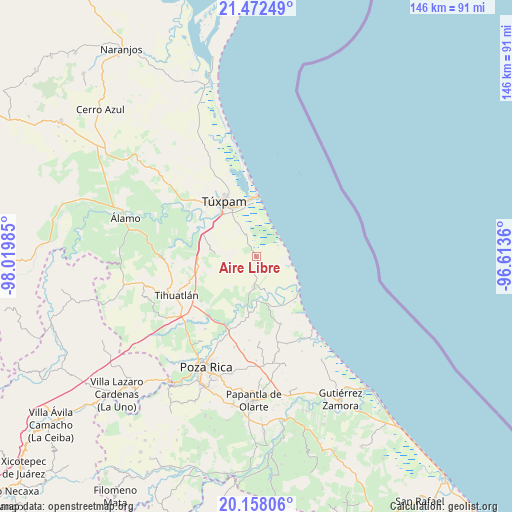
Aire Libre GPS coordinates[2]
20° 49' 0.156" North, 97° 19' 0.192" West
| Map corner | latitude | longitude |
|---|---|---|
| Upper-left | 21.47249°, | -98.01985° |
| Center: | 20.81671°, | -97.31672° |
| Lower-right: | 20.15806°, | -96.6136° |
| Map W x H: | 146.2×146.2 km | = 90.8×90.8mi |
| max Lat: | 32.7° ⇑26.5% North |
| Aire Libre: | 20.81671° |
| min Lat: | ⇓73.5% South 14.53588° |
| min Long | Aire Libre | max Long |
| -117.105° | -97.31672° | -86.73105° |
| W 71.4%⇐ | ⇒28.6% E |
Elevation
Elevation of Aire Libre is 10 m = 33 ft, and this is 1243.7 m = 4080 ft below average elevation for this country.
| Max E: |
3497 m = 11473 ft | 97% |
| Avg. | 1253.7 m = 4113 ft | |
| Aire Libre | 10 m = 33 ft | |
Min E: |
-1 m = -3 ft | 3% |
See also: Mexico elevation on elevation.city.
Geographical zone
Aire Libre is located in North Torrid zone (between Equator and Tropic of Cancer). Distance of this Northern Tropic circle is 291.3 km =181 mi to North.| Distance of | km | miles | from Aire Libre |
|---|---|---|---|
| North Pole | 7692.5 | 4779.9 | to North |
| Arctic Circle | 5086.6 | 3160.7 | to North |
| Tropic Cancer | 291.3 | 181 | to North |
| Equator | 2314.6 | 1438.2 | to South |


Nearby cities:
15 places around Aire Libre: (largest is in red/bold)
• Barrio Acosta Lagunes
13.6 km =8.5 mi,  178°
178°
• Cazones de Herrera
12.5 km =7.8 mi, 176°
• Chacoaco
11.1 km =6.9 mi,  330°
330°
• Cobos
14.5 km =9 mi,  340°
340°
• Coyol Norte
12.7 km =7.9 mi,  131°
131°
• El Salto de la Reforma
6.7 km =4.2 mi,  244°
244°
• El Sauce
10.4 km =6.5 mi,  197°
197°
• La Ceiba
6.7 km =4.2 mi,  140°
140°
• La Encantada
11.1 km =6.9 mi,  149°
149°
• La Victoria (La Peñita)
14.6 km =9.1 mi, 336°
• Laja del Tubo
8.9 km =5.5 mi,  231°
231°
• Manlio Fabio Altamirano
7.7 km =4.8 mi, 183°
• Nuevo Tejamanil
13.1 km =8.1 mi,  217°
217°
• Peña de Afuera
5.5 km =3.4 mi,  291°
291°
• Praxedis Guerrero (Kilómetro 18)
1.9 km =1.2 mi,  166°
166°
Sources, notices
• [Note1] Compared only with cities in Mexico existing in our database
• [Src1] Map data: © OpenStreetMap contributors (CC-BY-SA)
• [Src2] Other city data from geonames.org with taken over terms of usage.
• [Src3] Geographical zone / Annual Mean Temperature by Robert A. Rohde @ Wikipedia
