Españita geodata
Españita (Guanajuato) is a populated place; located in Mexico in America/Mexico_City (GMT-6) time zone. With population of 561 people, there are 15205 cities with bigger population in this country. Compared to other cities in Mexico, 75.2% of cities are located further ↓South; 68.8% of cities are located further →East and 82.4% of cities have lower elevation than Españita. Note1


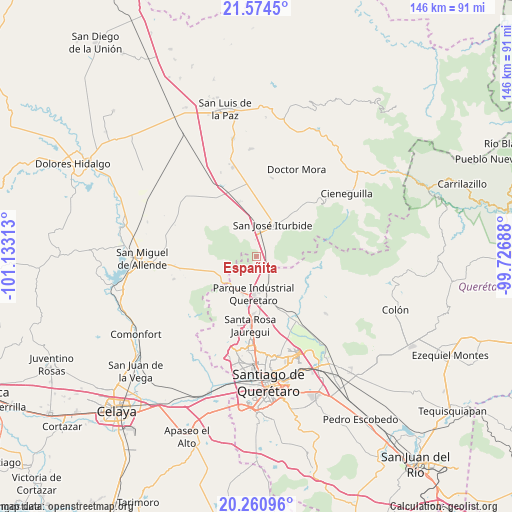
Españita GPS coordinates[2]
20° 55' 9.012" North, 100° 25' 48" West
| Map corner | latitude | longitude |
|---|---|---|
| Upper-left | 21.5745°, | -101.13313° |
| Center: | 20.91917°, | -100.43° |
| Lower-right: | 20.26096°, | -99.72688° |
| Map W x H: | 146.1×146.1 km | = 90.8×90.8mi |
| max Lat: | 32.7° ⇑24.8% North |
| Españita: | 20.91917° |
| min Lat: | ⇓75.2% South 14.53588° |
| min Long | Españita | max Long |
| -117.105° | -100.43° | -86.73105° |
| W 31.2%⇐ | ⇒68.8% E |
Elevation
Elevation of Españita is 2198 m = 7211 ft, and this is 944.3 m = 3098 ft above average elevation for this country.
| Max E: |
3497 m = 11473 ft | 17.6% |
| Españita | 2198 m 7211 ft | |
| Avg. | 1253.7 m = 4113 ft | |
Min E: |
-1 m = -3 ft | 82.4% |
See also: Mexico elevation on elevation.city.
Geographical zone
Españita is located in North Torrid zone (between Equator and Tropic of Cancer). Distance of this Northern Tropic circle is 279.9 km =173.9 mi to North.| Distance of | km | miles | from Españita |
|---|---|---|---|
| North Pole | 7681.1 | 4772.8 | to North |
| Arctic Circle | 5075.2 | 3153.6 | to North |
| Tropic Cancer | 279.9 | 173.9 | to North |
| Equator | 2326 | 1445.3 | to South |


Nearby cities:
15 places around Españita: (largest is in red/bold)
• Arenal de Abajo
6.5 km =4 mi,  341°
341°
• El Cerrito del Arenal
5.8 km =3.6 mi,  354°
354°
• Jofrito
6.5 km =4 mi,  169°
169°
• La Cantera
6.7 km =4.2 mi,  13°
13°
• La Cinta
5 km =3.1 mi, 10°
• La Huerta
7.7 km =4.8 mi,  17°
17°
• La Luz
5.7 km =3.5 mi,  188°
188°
• La Palma
5.5 km =3.4 mi,  132°
132°
• La Versolilla
7.4 km =4.6 mi, 133°
• Medina
4.6 km =2.9 mi, 125°
• Ojo de Agua
4.2 km =2.6 mi,  156°
156°
• Palo Alto
6.6 km =4.1 mi,  151°
151°
• Puerto de Carroza
3 km =1.9 mi,  140°
140°
• Ranchito Nuevo de Buenavistilla
4.7 km =2.9 mi,  59°
59°
• San Diego de las Trasquilas
4.1 km =2.5 mi,  65°
65°
Sources, notices
• [Note1] Compared only with cities in Mexico existing in our database
• [Src1] Map data: © OpenStreetMap contributors (CC-BY-SA)
• [Src2] Other city data from geonames.org with taken over terms of usage.
• [Src3] Geographical zone / Annual Mean Temperature by Robert A. Rohde @ Wikipedia
