Arenal de Abajo geodata
Arenal de Abajo (Guanajuato) is a populated place; located in Mexico in America/Mexico_City (GMT-6) time zone. With population of 533 people, there are 15888 cities with bigger population in this country. Compared to other cities in Mexico, 76.1% of cities are located further ↓South; 69% of cities are located further →East and 80.8% of cities have lower elevation than Arenal de Abajo. Note1


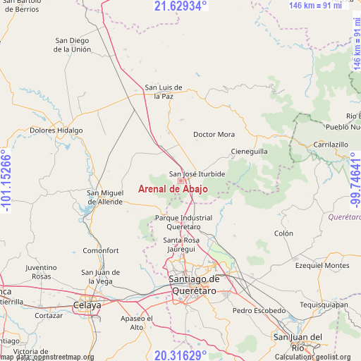
Arenal de Abajo GPS coordinates[2]
20° 58' 27.336" North, 100° 26' 58.308" West
| Map corner | latitude | longitude |
|---|---|---|
| Upper-left | 21.62934°, | -101.15266° |
| Center: | 20.97426°, | -100.44953° |
| Lower-right: | 20.31629°, | -99.74641° |
| Map W x H: | 146×146 km | = 90.7×90.7mi |
| max Lat: | 32.7° ⇑23.9% North |
| Arenal de Abajo: | 20.97426° |
| min Lat: | ⇓76.1% South 14.53588° |
| min Long | Arenal de Abajo | max Long |
| -117.105° | -100.44953° | -86.73105° |
| W 31%⇐ | ⇒69% E |
Elevation
Elevation of Arenal de Abajo is 2160 m = 7087 ft, and this is 906.3 m = 2973 ft above average elevation for this country.
| Max E: |
3497 m = 11473 ft | 19.2% |
| Arenal de Abajo | 2160 m 7087 ft | |
| Avg. | 1253.7 m = 4113 ft | |
Min E: |
-1 m = -3 ft | 80.8% |
See also: Mexico elevation on elevation.city.
Geographical zone
Arenal de Abajo is located in North Torrid zone (between Equator and Tropic of Cancer). Distance of this Northern Tropic circle is 273.8 km =170.1 mi to North.| Distance of | km | miles | from Arenal de Abajo |
|---|---|---|---|
| North Pole | 7674.9 | 4769 | to North |
| Arctic Circle | 5069.1 | 3149.8 | to North |
| Tropic Cancer | 273.8 | 170.1 | to North |
| Equator | 2332.1 | 1449.1 | to South |


Nearby cities:
15 places around Arenal de Abajo: (largest is in red/bold)
• Cinco de Mayo
5.9 km =3.7 mi,  35°
35°
• El Cerrito del Arenal
1.5 km =0.9 mi,  104°
104°
• El Pinito
6.1 km =3.8 mi,  63°
63°
• Españita
6.5 km =4 mi,  161°
161°
• Galomo
9.7 km =6 mi,  8°
8°
• La Cantera
3.7 km =2.3 mi,  84°
84°
• La Cinta
3.2 km =2 mi,  113°
113°
• La Huerta
4.6 km =2.9 mi,  74°
74°
• Las Adjuntas
10.3 km =6.4 mi,  21°
21°
• Medina
10.5 km =6.5 mi,  146°
146°
• Prados del Rosario
7.9 km =4.9 mi,  48°
48°
• Puerto de Carroza
9.3 km =5.8 mi, 154°
• Ranchito Nuevo de Buenavistilla
7.2 km =4.5 mi,  121°
121°
• San Diego de las Trasquilas
7.3 km =4.5 mi,  127°
127°
• San José Iturbide
7.4 km =4.6 mi, 65°
Sources, notices
• [Note1] Compared only with cities in Mexico existing in our database
• [Src1] Map data: © OpenStreetMap contributors (CC-BY-SA)
• [Src2] Other city data from geonames.org with taken over terms of usage.
• [Src3] Geographical zone / Annual Mean Temperature by Robert A. Rohde @ Wikipedia
