Las Pilas geodata
Las Pilas (Oaxaca) is a populated place; located in Mexico in America/Mexico_City (GMT-6) time zone. With population of 557 people, there are 15314 cities with bigger population in this country. Compared to other cities in Mexico, 97.9% of cities are located further ↑North; 78.6% of cities are located further ←West and 75.6% of cities have higher elevation than Las Pilas. Note1


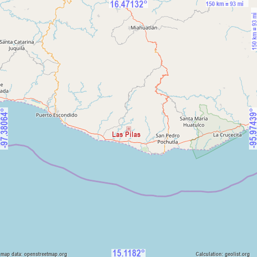
Las Pilas GPS coordinates[2]
15° 47' 45.204" North, 96° 40' 39.036" West
| Map corner | latitude | longitude |
|---|---|---|
| Upper-left | 16.47132°, | -97.38064° |
| Center: | 15.79589°, | -96.67751° |
| Lower-right: | 15.1182°, | -95.97439° |
| Map W x H: | 150.5×150.5 km | = 93.5×93.5mi |
| max Lat: | 32.7° ⇑97.9% North |
| Las Pilas: | 15.79589° |
| min Lat: | ⇓2.1% South 14.53588° |
| min Long | Las Pilas | max Long |
| -117.105° | -96.67751° | -86.73105° |
| W 78.6%⇐ | ⇒21.4% E |
Elevation
Elevation of Las Pilas is 202 m = 663 ft, and this is 1051.7 m = 3450 ft below average elevation for this country.
| Max E: |
3497 m = 11473 ft | 75.6% |
| Avg. | 1253.7 m = 4113 ft | |
| Las Pilas | 202 m = 663 ft | |
Min E: |
-1 m = -3 ft | 24.4% |
See also: Mexico elevation on elevation.city.
Geographical zone
Las Pilas is located in North Torrid zone (between Equator and Tropic of Cancer). Distance of this Northern Tropic circle is 849.6 km =527.9 mi to North.| Distance of | km | miles | from Las Pilas |
|---|---|---|---|
| North Pole | 8250.7 | 5126.7 | to North |
| Arctic Circle | 5644.8 | 3507.5 | to North |
| Tropic Cancer | 849.6 | 527.9 | to North |
| Equator | 1756.3 | 1091.3 | to South |


Nearby cities:
15 places around Las Pilas: (largest is in red/bold)
• Bajos de Santo Domingo
3.8 km =2.4 mi,  347°
347°
• Barrio Nuevo
4.8 km =3 mi,  29°
29°
• El Camalote
10.3 km =6.4 mi, 34°
• Las Cuevas
7.8 km =4.8 mi,  82°
82°
• Los Horcones
11.7 km =7.3 mi,  67°
67°
• Macahuitera
6.8 km =4.2 mi,  56°
56°
• Magdalena Loxícha
11.9 km =7.4 mi, 352°
• Piedra del Sol
9.9 km =6.2 mi, 30°
• San Antonio
13.6 km =8.5 mi,  130°
130°
• San Francisco Cozoaltepec
5.4 km =3.4 mi,  292°
292°
• San Francisco Loxicha
14.1 km =8.8 mi, 29°
• San Isidro del Palmar
11.2 km =7 mi,  139°
139°
• San José Piedras Negras
10.3 km =6.4 mi, 63°
• San Juanito o la Botija
11.6 km =7.2 mi,  267°
267°
• Santo Domingo de Morelos
4.4 km =2.7 mi,  14°
14°
Sources, notices
• [Note1] Compared only with cities in Mexico existing in our database
• [Src1] Map data: © OpenStreetMap contributors (CC-BY-SA)
• [Src2] Other city data from geonames.org with taken over terms of usage.
• [Src3] Geographical zone / Annual Mean Temperature by Robert A. Rohde @ Wikipedia
