Agua Zarca geodata
Agua Zarca (Guerrero) is a populated place; located in Mexico in America/Mexico_City (GMT-6) time zone. With population of 551 people, there are 15478 cities with bigger population in this country. Compared to other cities in Mexico, 82.2% of cities are located further ↑North; 51.7% of cities are located further →East and 51% of cities have higher elevation than Agua Zarca. Note1


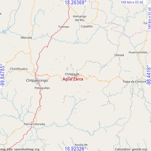
Agua Zarca GPS coordinates[2]
17° 35' 40.992" North, 99° 8' 40.992" West
| Map corner | latitude | longitude |
|---|---|---|
| Upper-left | 18.26369°, | -99.84785° |
| Center: | 17.59472°, | -99.14472° |
| Lower-right: | 16.92326°, | -98.4416° |
| Map W x H: | 149×149 km | = 92.6×92.6mi |
| max Lat: | 32.7° ⇑82.2% North |
| Agua Zarca: | 17.59472° |
| min Lat: | ⇓17.8% South 14.53588° |
| min Long | Agua Zarca | max Long |
| -117.105° | -99.14472° | -86.73105° |
| W 48.3%⇐ | ⇒51.7% E |
Elevation
Elevation of Agua Zarca is 1381 m = 4531 ft, and this is 127.3 m = 418 ft above average elevation for this country.
| Max E: |
3497 m = 11473 ft | 51% |
| Agua Zarca | 1381 m 4531 ft | |
| Avg. | 1253.7 m = 4113 ft | |
Min E: |
-1 m = -3 ft | 49% |
See also: Mexico elevation on elevation.city.
Geographical zone
Agua Zarca is located in North Torrid zone (between Equator and Tropic of Cancer). Distance of this Northern Tropic circle is 649.6 km =403.6 mi to North.| Distance of | km | miles | from Agua Zarca |
|---|---|---|---|
| North Pole | 8050.7 | 5002.5 | to North |
| Arctic Circle | 5444.8 | 3383.2 | to North |
| Tropic Cancer | 649.6 | 403.6 | to North |
| Equator | 1956.3 | 1215.6 | to South |


Nearby cities:
15 places around Agua Zarca: (largest is in red/bold)
• Amate Amarillo
6.4 km =4 mi,  261°
261°
• Atzacoaloya
5.4 km =3.4 mi,  171°
171°
• Ayahualco
5.4 km =3.4 mi,  306°
306°
• Chilapa de Álvarez
3.1 km =1.9 mi,  279°
279°
• Los Magueyes
4.7 km =2.9 mi,  322°
322°
• Macuixcatlán
4.1 km =2.5 mi,  202°
202°
• Nejapa
2.1 km =1.3 mi,  359°
359°
• Ocuituco (Acuituco)
5.7 km =3.5 mi,  232°
232°
• Pantitlán
6.2 km =3.9 mi,  36°
36°
• Santa Catarina
6.1 km =3.8 mi,  211°
211°
• Santa Cruz
6.7 km =4.2 mi,  24°
24°
• Tepetlacingo
3.6 km =2.2 mi,  182°
182°
• Tlanipatla
6.8 km =4.2 mi, 181°
• Trigomila
2.1 km =1.3 mi,  129°
129°
• Zinzintitlán
6.4 km =4 mi,  187°
187°
Sources, notices
• [Note1] Compared only with cities in Mexico existing in our database
• [Src1] Map data: © OpenStreetMap contributors (CC-BY-SA)
• [Src2] Other city data from geonames.org with taken over terms of usage.
• [Src3] Geographical zone / Annual Mean Temperature by Robert A. Rohde @ Wikipedia
