Las Tenerías (Las Tenerías de Tepetongo) geodata
Las Tenerías (Las Tenerías de Tepetongo) (Michoacán) is a populated place; located in Mexico in America/Mexico_City (GMT-6) time zone. With population of 529 people, there are 15998 cities with bigger population in this country. Compared to other cities in Mexico, 55.1% of cities are located further ↓South; 65.5% of cities are located further →East and 88.3% of cities have lower elevation than Las Tenerías (Las Tenerías de Tepetongo). Note1
Current local time in Las Tenerías (Las Tenerías de Tepetongo):
10:29 AM, MondayDifference from your time zone: hours


Las Tenerías (Las Tenerías de Tepetongo) GPS coordinates[2]
19° 54' 16.992" North, 100° 7' 24.996" West
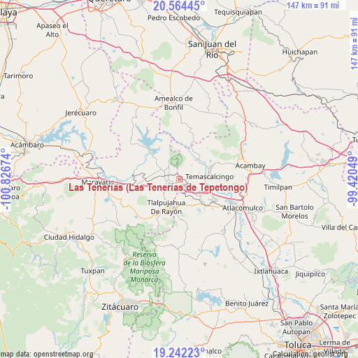
| Map corner | latitude | longitude |
|---|---|---|
| Upper-left | 20.56445°, | -100.82674° |
| Center: | 19.90472°, | -100.12361° |
| Lower-right: | 19.24223°, | -99.42049° |
| Map W x H: | 147×147 km | = 91.3×91.3mi |
| max Lat: | 32.7° ⇑44.9% North |
| Las Tenerías (Las Tenerías de Tepetongo): | 19.90472° |
| min Lat: | ⇓55.1% South 14.53588° |
| min Long | Las Tenerías ( | max Long |
| -117.105° | -100.12361° | -86.73105° |
| W 34.5%⇐ | ⇒65.5% E |
Elevation
Elevation of Las Tenerías (Las Tenerías de Tepetongo) is 2351 m = 7713 ft, and this is 1097.3 m = 3600 ft above average elevation for this country.
| Max E: |
3497 m = 11473 ft | 11.7% |
| Las Tenerías (Las Tenerías de Tepetongo) | 2351 m 7713 ft | |
| Avg. | 1253.7 m = 4113 ft | |
Min E: |
-1 m = -3 ft | 88.3% |
See also: Mexico elevation on elevation.city.
Geographical zone
Las Tenerías (Las Tenerías de Tepetongo) is located in North Torrid zone (between Equator and Tropic of Cancer). Distance of this Northern Tropic circle is 392.7 km =244 mi to North.| Distance of | km | miles | from Las Tenerías (Las Tenerías de Tepetongo) |
|---|---|---|---|
| North Pole | 7793.9 | 4842.9 | to North |
| Arctic Circle | 5188 | 3223.7 | to North |
| Tropic Cancer | 392.7 | 244 | to North |
| Equator | 2213.2 | 1375.2 | to South |


Nearby cities:
15 places around Las Tenerías (Las Tenerías de Tepetongo): (largest is in red/bold)
• Agua Caliente
5.1 km =3.2 mi,  264°
264°
• Barrio la Estrellita
10.2 km =6.3 mi,  182°
182°
• Contepec
6.9 km =4.3 mi,  322°
322°
• El Capulín
4.3 km =2.7 mi,  223°
223°
• El Césped
3 km =1.9 mi,  214°
214°
• El Encino
4.8 km =3 mi,  280°
280°
• El Gigante
9.6 km =6 mi,  230°
230°
• El Rodeo
6.5 km =4 mi,  50°
50°
• La Huerta
10 km =6.2 mi,  83°
83°
• Mesa de Bañi
8.4 km =5.2 mi,  118°
118°
• San Francisco Solis
8.7 km =5.4 mi,  71°
71°
• Santa María Canchesdá
9 km =5.6 mi,  127°
127°
• Tepetongo
1.1 km =0.7 mi,  293°
293°
• Venta de Bravo
6.9 km =4.3 mi, 228°
• Zaragoza (Puerto de Medina)
3.5 km =2.2 mi,  169°
169°
Sources, notices
• [Note1] Compared only with cities in Mexico existing in our database
• [Src1] Map data: © OpenStreetMap contributors (CC-BY-SA)
• [Src2] Other city data from geonames.org with taken over terms of usage.
• [Src3] Geographical zone / Annual Mean Temperature by Robert A. Rohde @ Wikipedia
