Contepec geodata
Contepec (State of Mexico) is a seat of a second-order administrative division; located in Mexico in America/Mexico_City (GMT-6) time zone. With population of 4,184 people, there are 2190 cities with bigger population in this country. Compared to other cities in Mexico, 56% of cities are located further ↓South; 66% of cities are located further →East and 92.2% of cities have lower elevation than Contepec. Note1


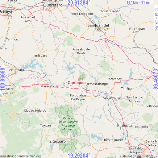
Contepec GPS coordinates[2]
19° 57' 15.552" North, 100° 9' 49.86" West
| Map corner | latitude | longitude |
|---|---|---|
| Upper-left | 20.61384°, | -100.86698° |
| Center: | 19.95432°, | -100.16385° |
| Lower-right: | 19.29204°, | -99.46073° |
| Map W x H: | 147×147 km | = 91.3×91.3mi |
| max Lat: | 32.7° ⇑44% North |
| Contepec: | 19.95432° |
| min Lat: | ⇓56% South 14.53588° |
| min Long | Contepec | max Long |
| -117.105° | -100.16385° | -86.73105° |
| W 34%⇐ | ⇒66% E |
Elevation
Elevation of Contepec is 2492 m = 8176 ft, and this is 1238.3 m = 4063 ft above average elevation for this country.
| Max E: |
3497 m = 11473 ft | 7.8% |
| Contepec | 2492 m 8176 ft | |
| Avg. | 1253.7 m = 4113 ft | |
Min E: |
-1 m = -3 ft | 92.2% |
See also: Mexico elevation on elevation.city.
Geographical zone
Contepec is located in North Torrid zone (between Equator and Tropic of Cancer). Distance of this Northern Tropic circle is 387.2 km =240.6 mi to North.| Distance of | km | miles | from Contepec |
|---|---|---|---|
| North Pole | 7788.3 | 4839.4 | to North |
| Arctic Circle | 5182.5 | 3220.3 | to North |
| Tropic Cancer | 387.2 | 240.6 | to North |
| Equator | 2218.7 | 1378.6 | to South |


Nearby cities:
15 places around Contepec: (largest is in red/bold)
• Agua Caliente
6.1 km =3.8 mi,  187°
187°
• Atotonilco
6.4 km =4 mi,  256°
256°
• Buenavista
8.3 km =5.2 mi,  236°
236°
• El Capulín
8.7 km =5.4 mi,  171°
171°
• El Césped
8.4 km =5.2 mi,  162°
162°
• El Encino
4.7 km =2.9 mi, 186°
• El Rodeo
9.3 km =5.8 mi,  98°
98°
• El Tejocote (La Loma)
10.4 km =6.5 mi,  10°
10°
• Las Tenerías (Las Tenerías de Tepetongo)
6.9 km =4.3 mi,  142°
142°
• Llano Largo (Santa Rosa de Lima)
8.1 km =5 mi,  341°
341°
• San Antonio Solís
9.6 km =6 mi,  58°
58°
• Tepetongo
6 km =3.7 mi,  147°
147°
• Tepuxtepec
7.7 km =4.8 mi,  302°
302°
• Venta de Bravo
10.1 km =6.3 mi, 185°
• Zaragoza (Puerto de Medina)
10.2 km =6.3 mi, 151°
Sources, notices
• [Note1] Compared only with cities in Mexico existing in our database
• [Src1] Map data: © OpenStreetMap contributors (CC-BY-SA)
• [Src2] Other city data from geonames.org with taken over terms of usage.
• [Src3] Geographical zone / Annual Mean Temperature by Robert A. Rohde @ Wikipedia
