Bellavista geodata
Bellavista (Chiapas) is a populated place; located in Mexico in America/Mexico_City (GMT-6) time zone. With population of 525 people, there are 16085 cities with bigger population in this country. Compared to other cities in Mexico, 99.3% of cities are located further ↑North; 94.5% of cities are located further ←West and 56% of cities have higher elevation than Bellavista. Note1


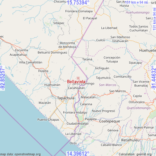
Bellavista GPS coordinates[2]
15° 4' 33.996" North, 92° 8' 57.984" West
| Map corner | latitude | longitude |
|---|---|---|
| Upper-left | 15.75394°, | -92.85257° |
| Center: | 15.07611°, | -92.14944° |
| Lower-right: | 14.39612°, | -91.44632° |
| Map W x H: | 151×151 km | = 93.8×93.8mi |
| max Lat: | 32.7° ⇑99.3% North |
| Bellavista: | 15.07611° |
| min Lat: | ⇓0.7% South 14.53588° |
| min Long | Bellavista | max Long |
| -117.105° | -92.14944° | -86.73105° |
| W 94.5%⇐ | ⇒5.5% E |
Elevation
Elevation of Bellavista is 1158 m = 3799 ft, and this is 95.7 m = 314 ft below average elevation for this country.
| Max E: |
3497 m = 11473 ft | 56% |
| Avg. | 1253.7 m = 4113 ft | |
| Bellavista | 1158 m = 3799 ft | |
Min E: |
-1 m = -3 ft | 44% |
See also: Mexico elevation on elevation.city.
Geographical zone
Bellavista is located in North Torrid zone (between Equator and Tropic of Cancer). Distance of this Northern Tropic circle is 929.6 km =577.6 mi to North.| Distance of | km | miles | from Bellavista |
|---|---|---|---|
| North Pole | 8330.8 | 5176.5 | to North |
| Arctic Circle | 5724.9 | 3557.3 | to North |
| Tropic Cancer | 929.6 | 577.6 | to North |
| Equator | 1676.3 | 1041.6 | to South |


Nearby cities:
15 places around Bellavista: (largest is in red/bold)
• Agustín de Iturbide
5.3 km =3.3 mi,  268°
268°
• Ahuacatlán
5.2 km =3.2 mi,  219°
219°
• Alpujarras
2.4 km =1.5 mi,  264°
264°
• Benito Juárez
5.1 km =3.2 mi,  242°
242°
• Dos de Mayo
6 km =3.7 mi,  179°
179°
• El Carmen
5.3 km =3.3 mi,  196°
196°
• El Platanar
1.6 km =1 mi,  301°
301°
• El Progreso
5.3 km =3.3 mi,  282°
282°
• El Águila
4.3 km =2.7 mi, 296°
• Faja de Oro
4.9 km =3 mi,  188°
188°
• Guatimoc
3.3 km =2.1 mi, 187°
• Mixcum
5.7 km =3.5 mi,  170°
170°
• Once de Abril
2.8 km =1.7 mi,  163°
163°
• San Jerónimo
4.1 km =2.5 mi, 161°
• Trinidad
5.5 km =3.4 mi,  141°
141°
Sources, notices
• [Note1] Compared only with cities in Mexico existing in our database
• [Src1] Map data: © OpenStreetMap contributors (CC-BY-SA)
• [Src2] Other city data from geonames.org with taken over terms of usage.
• [Src3] Geographical zone / Annual Mean Temperature by Robert A. Rohde @ Wikipedia
