Las Flores geodata
Las Flores (Hidalgo) is a populated place; located in Mexico in America/Mexico_City (GMT-6) time zone. With population of 525 people, there are 16085 cities with bigger population in this country. Compared to other cities in Mexico, 58% of cities are located further ↓South; 54.2% of cities are located further ←West and 88.1% of cities have lower elevation than Las Flores. Note1


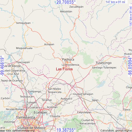
Las Flores GPS coordinates[2]
20° 2' 57.984" North, 98° 45' 47.016" West
| Map corner | latitude | longitude |
|---|---|---|
| Upper-left | 20.70855°, | -99.46619° |
| Center: | 20.04944°, | -98.76306° |
| Lower-right: | 19.38755°, | -98.05994° |
| Map W x H: | 146.9×146.9 km | = 91.3×91.3mi |
| max Lat: | 32.7° ⇑42% North |
| Las Flores: | 20.04944° |
| min Lat: | ⇓58% South 14.53588° |
| min Long | Las Flores | max Long |
| -117.105° | -98.76306° | -86.73105° |
| W 54.2%⇐ | ⇒45.8% E |
Elevation
Elevation of Las Flores is 2346 m = 7697 ft, and this is 1092.3 m = 3584 ft above average elevation for this country.
| Max E: |
3497 m = 11473 ft | 11.9% |
| Las Flores | 2346 m 7697 ft | |
| Avg. | 1253.7 m = 4113 ft | |
Min E: |
-1 m = -3 ft | 88.1% |
See also: Mexico elevation on elevation.city.
Geographical zone
Las Flores is located in North Torrid zone (between Equator and Tropic of Cancer). Distance of this Northern Tropic circle is 376.6 km =234 mi to North.| Distance of | km | miles | from Las Flores |
|---|---|---|---|
| North Pole | 7777.8 | 4832.9 | to North |
| Arctic Circle | 5171.9 | 3213.7 | to North |
| Tropic Cancer | 376.6 | 234 | to North |
| Equator | 2229.3 | 1385.2 | to South |


Nearby cities:
15 places around Las Flores: (largest is in red/bold)
• Bosques del Mineral
1.6 km =1 mi,  308°
308°
• Cipreses
1.1 km =0.7 mi,  336°
336°
• El Paraíso
2.6 km =1.6 mi,  58°
58°
• El Roble
1.1 km =0.7 mi,  27°
27°
• El Venado
1.5 km =0.9 mi,  11°
11°
• Forjadores de Pachuca
0.6 km =0.4 mi,  357°
357°
• La Colonia
1 km =0.6 mi, 307°
• Los Tuzos
0.9 km =0.6 mi,  54°
54°
• Magisterio Digno
1 km =0.6 mi,  323°
323°
• Nuevo Centro de Población Agrícola el Chacón
3.4 km =2.1 mi, 46°
• Privada Quinta Bonita
1.8 km =1.1 mi,  334°
334°
• Rinconadas de San Francisco
1.9 km =1.2 mi, 344°
• Rinconadas del Venado I
1.6 km =1 mi, 358°
• San José Palma Gorda
3.3 km =2.1 mi,  157°
157°
• Tulipanes
1.3 km =0.8 mi, 340°
Sources, notices
• [Note1] Compared only with cities in Mexico existing in our database
• [Src1] Map data: © OpenStreetMap contributors (CC-BY-SA)
• [Src2] Other city data from geonames.org with taken over terms of usage.
• [Src3] Geographical zone / Annual Mean Temperature by Robert A. Rohde @ Wikipedia
