La Estación geodata
La Estación (Querétaro) is a populated place; located in Mexico in America/Mexico_City (GMT-6) time zone. With population of 516 people, there are 16314 cities with bigger population in this country. Compared to other cities in Mexico, 76.9% of cities are located further ↓South; 60.7% of cities are located further →East and 53.3% of cities have higher elevation than La Estación. Note1


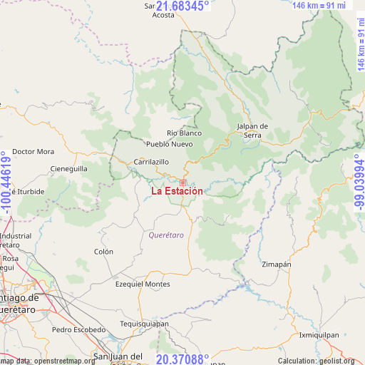
La Estación GPS coordinates[2]
21° 1' 42.996" North, 99° 44' 35.016" West
| Map corner | latitude | longitude |
|---|---|---|
| Upper-left | 21.68345°, | -100.44619° |
| Center: | 21.02861°, | -99.74306° |
| Lower-right: | 20.37088°, | -99.03994° |
| Map W x H: | 145.9×145.9 km | = 90.7×90.7mi |
| max Lat: | 32.7° ⇑23.1% North |
| La Estación: | 21.02861° |
| min Lat: | ⇓76.9% South 14.53588° |
| min Long | La Estación | max Long |
| -117.105° | -99.74306° | -86.73105° |
| W 39.3%⇐ | ⇒60.7% E |
Elevation
Elevation of La Estación is 1278 m = 4193 ft, and this is 24.3 m = 80 ft above average elevation for this country.
| Max E: |
3497 m = 11473 ft | 53.3% |
| La Estación | 1278 m 4193 ft | |
| Avg. | 1253.7 m = 4113 ft | |
Min E: |
-1 m = -3 ft | 46.7% |
See also: Mexico elevation on elevation.city.
Geographical zone
La Estación is located in North Torrid zone (between Equator and Tropic of Cancer). Distance of this Northern Tropic circle is 267.8 km =166.4 mi to North.| Distance of | km | miles | from La Estación |
|---|---|---|---|
| North Pole | 7668.9 | 4765.2 | to North |
| Arctic Circle | 5063 | 3146 | to North |
| Tropic Cancer | 267.8 | 166.4 | to North |
| Equator | 2338.2 | 1452.9 | to South |


Nearby cities:
15 places around La Estación: (largest is in red/bold)
• Agua Fría
15.3 km =9.5 mi,  334°
334°
• Barrio de Casas Viejas
22.3 km =13.9 mi,  235°
235°
• Camargo
8.6 km =5.3 mi,  6°
6°
• Higuerillas
12.7 km =7.9 mi,  190°
190°
• Horno de Cal
23.2 km =14.4 mi,  231°
231°
• Los Juárez
20.2 km =12.6 mi,  151°
151°
• Peña Blanca
1.7 km =1.1 mi,  44°
44°
• Peñamiller
8.1 km =5 mi,  290°
290°
• Pinal de Amoles
16.9 km =10.5 mi,  45°
45°
• San Joaquín
22.3 km =13.9 mi,  124°
124°
• San Miguel Palmas
24.3 km =15.1 mi, 288°
• San Pablo Tolimán
25.1 km =15.6 mi,  220°
220°
• Tolimán
23.6 km =14.7 mi, 235°
• Villa Emiliano Zapata (Extoraz)
3.6 km =2.2 mi,  278°
278°
• Vizarrón
22 km =13.7 mi,  173°
173°
Sources, notices
• [Note1] Compared only with cities in Mexico existing in our database
• [Src1] Map data: © OpenStreetMap contributors (CC-BY-SA)
• [Src2] Other city data from geonames.org with taken over terms of usage.
• [Src3] Geographical zone / Annual Mean Temperature by Robert A. Rohde @ Wikipedia
