San Miguel Palmas geodata
San Miguel Palmas (Querétaro) is a populated place; located in Mexico in America/Mexico_City (GMT-6) time zone. With population of 560 people, there are 15231 cities with bigger population in this country. Compared to other cities in Mexico, 77.8% of cities are located further ↓South; 63.6% of cities are located further →East and 50.6% of cities have lower elevation than San Miguel Palmas. Note1


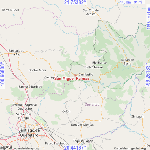
San Miguel Palmas GPS coordinates[2]
21° 5' 57.444" North, 99° 57' 53.82" West
| Map corner | latitude | longitude |
|---|---|---|
| Upper-left | 21.75382°, | -100.66808° |
| Center: | 21.09929°, | -99.96495° |
| Lower-right: | 20.44187°, | -99.26183° |
| Map W x H: | 145.9×145.9 km | = 90.7×90.7mi |
| max Lat: | 32.7° ⇑22.2% North |
| San Miguel Palmas: | 21.09929° |
| min Lat: | ⇓77.8% South 14.53588° |
| min Long | San Miguel Palm | max Long |
| -117.105° | -99.96495° | -86.73105° |
| W 36.4%⇐ | ⇒63.6% E |
Elevation
Elevation of San Miguel Palmas is 1466 m = 4810 ft, and this is 212.3 m = 697 ft above average elevation for this country.
| Max E: |
3497 m = 11473 ft | 49.4% |
| San Miguel Palmas | 1466 m 4810 ft | |
| Avg. | 1253.7 m = 4113 ft | |
Min E: |
-1 m = -3 ft | 50.6% |
See also: Mexico elevation on elevation.city.
Geographical zone
San Miguel Palmas is located in North Torrid zone (between Equator and Tropic of Cancer). Distance of this Northern Tropic circle is 259.9 km =161.5 mi to North.| Distance of | km | miles | from San Miguel Palmas |
|---|---|---|---|
| North Pole | 7661 | 4760.3 | to North |
| Arctic Circle | 5055.2 | 3141.2 | to North |
| Tropic Cancer | 259.9 | 161.5 | to North |
| Equator | 2346 | 1457.7 | to South |


Nearby cities:
15 places around San Miguel Palmas: (largest is in red/bold)
• Agua Fría
17.5 km =10.9 mi,  70°
70°
• Barrio de Casas Viejas
21.1 km =13.1 mi,  167°
167°
• Bomintzá
17.8 km =11.1 mi,  191°
191°
• Casa Blanca
18.7 km =11.6 mi,  181°
181°
• El Cerrito Parado
19.4 km =12.1 mi, 178°
• Fracción de Guadalupe
19.7 km =12.2 mi,  280°
280°
• Las Moras
20.7 km =12.9 mi,  262°
262°
• Los González
18.1 km =11.2 mi, 181°
• Mesa de Ramírez
19.1 km =11.9 mi, 187°
• Peñamiller
16.3 km =10.1 mi,  107°
107°
• Sabino de San Ambrosio
20.1 km =12.5 mi, 181°
• Santa Catarina
11.9 km =7.4 mi,  293°
293°
• Tierra Blanca
20.2 km =12.6 mi,  270°
270°
• Tolimán
21.5 km =13.4 mi, 170°
• Villa Emiliano Zapata (Extoraz)
20.8 km =12.9 mi, 110°
Sources, notices
• [Note1] Compared only with cities in Mexico existing in our database
• [Src1] Map data: © OpenStreetMap contributors (CC-BY-SA)
• [Src2] Other city data from geonames.org with taken over terms of usage.
• [Src3] Geographical zone / Annual Mean Temperature by Robert A. Rohde @ Wikipedia
