Tomatillo geodata
Tomatillo (Veracruz) is a populated place; located in Mexico in America/Mexico_City (GMT-6) time zone. With population of 515 people, there are 16340 cities with bigger population in this country. Compared to other cities in Mexico, 81.3% of cities are located further ↑North; 82.7% of cities are located further ←West and 80.9% of cities have higher elevation than Tomatillo. Note1


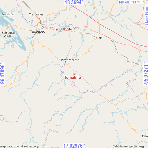
Tomatillo GPS coordinates[2]
17° 42' 2.988" North, 95° 46' 32.988" West
| Map corner | latitude | longitude |
|---|---|---|
| Upper-left | 18.3694°, | -96.47896° |
| Center: | 17.70083°, | -95.77583° |
| Lower-right: | 17.02976°, | -95.07271° |
| Map W x H: | 149×149 km | = 92.6×92.6mi |
| max Lat: | 32.7° ⇑81.3% North |
| Tomatillo: | 17.70083° |
| min Lat: | ⇓18.7% South 14.53588° |
| min Long | Tomatillo | max Long |
| -117.105° | -95.77583° | -86.73105° |
| W 82.7%⇐ | ⇒17.3% E |
Elevation
Elevation of Tomatillo is 84 m = 276 ft, and this is 1169.7 m = 3838 ft below average elevation for this country.
| Max E: |
3497 m = 11473 ft | 80.9% |
| Avg. | 1253.7 m = 4113 ft | |
| Tomatillo | 84 m = 276 ft | |
Min E: |
-1 m = -3 ft | 19.1% |
See also: Mexico elevation on elevation.city.
Geographical zone
Tomatillo is located in North Torrid zone (between Equator and Tropic of Cancer). Distance of this Northern Tropic circle is 637.8 km =396.3 mi to North.| Distance of | km | miles | from Tomatillo |
|---|---|---|---|
| North Pole | 8038.9 | 4995.1 | to North |
| Arctic Circle | 5433 | 3375.9 | to North |
| Tropic Cancer | 637.8 | 396.3 | to North |
| Equator | 1968.1 | 1222.9 | to South |


Nearby cities:
15 places around Tomatillo: (largest is in red/bold)
• Arenal Santa Ana
9.9 km =6.2 mi,  3°
3°
• Arroyo Zacate
3.7 km =2.3 mi,  322°
322°
• Arroyo de Piedra
16.2 km =10.1 mi,  208°
208°
• Boca del Monte
10.7 km =6.6 mi,  153°
153°
• Chilapa del Carmen
9.6 km =6 mi,  340°
340°
• El Nigromante
7.4 km =4.6 mi,  15°
15°
• La Nueva Era
3.5 km =2.2 mi,  265°
265°
• Montenegro la Lana
15.3 km =9.5 mi,  218°
218°
• Paso de San Jacobo
12.8 km =8 mi,  244°
244°
• Playa Vicente
15 km =9.3 mi,  345°
345°
• San José Río Manzo
11.6 km =7.2 mi,  252°
252°
• San Lorenzo
13.1 km =8.1 mi,  180°
180°
• Santa Teresa
10.9 km =6.8 mi,  93°
93°
• Tomate Río Manso
10.9 km =6.8 mi,  289°
289°
• Xochiapa
6 km =3.7 mi,  133°
133°
Sources, notices
• [Note1] Compared only with cities in Mexico existing in our database
• [Src1] Map data: © OpenStreetMap contributors (CC-BY-SA)
• [Src2] Other city data from geonames.org with taken over terms of usage.
• [Src3] Geographical zone / Annual Mean Temperature by Robert A. Rohde @ Wikipedia
