San Lorenzo geodata
San Lorenzo (Oaxaca) is a populated place; located in Mexico in America/Mexico_City (GMT-6) time zone. With population of 1,191 people, there are 7293 cities with bigger population in this country. Compared to other cities in Mexico, 82.3% of cities are located further ↑North; 82.7% of cities are located further ←West and 80.1% of cities have higher elevation than San Lorenzo. Note1


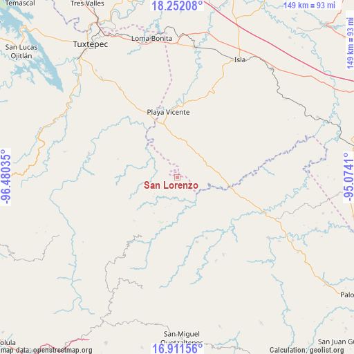
San Lorenzo GPS coordinates[2]
17° 34' 59.016" North, 95° 46' 37.992" West
| Map corner | latitude | longitude |
|---|---|---|
| Upper-left | 18.25208°, | -96.48035° |
| Center: | 17.58306°, | -95.77722° |
| Lower-right: | 16.91156°, | -95.0741° |
| Map W x H: | 149.1×149.1 km | = 92.6×92.6mi |
| max Lat: | 32.7° ⇑82.3% North |
| San Lorenzo: | 17.58306° |
| min Lat: | ⇓17.7% South 14.53588° |
| min Long | San Lorenzo | max Long |
| -117.105° | -95.77722° | -86.73105° |
| W 82.7%⇐ | ⇒17.3% E |
Elevation
Elevation of San Lorenzo is 94 m = 308 ft, and this is 1159.7 m = 3805 ft below average elevation for this country.
| Max E: |
3497 m = 11473 ft | 80.1% |
| Avg. | 1253.7 m = 4113 ft | |
| San Lorenzo | 94 m = 308 ft | |
Min E: |
-1 m = -3 ft | 19.9% |
See also: Mexico elevation on elevation.city.
Geographical zone
San Lorenzo is located in North Torrid zone (between Equator and Tropic of Cancer). Distance of this Northern Tropic circle is 650.9 km =404.5 mi to North.| Distance of | km | miles | from San Lorenzo |
|---|---|---|---|
| North Pole | 8052 | 5003.3 | to North |
| Arctic Circle | 5446.1 | 3384 | to North |
| Tropic Cancer | 650.9 | 404.5 | to North |
| Equator | 1955.1 | 1214.8 | to South |


Nearby cities:
15 places around San Lorenzo: (largest is in red/bold)
• Arroyo Blanco
10.2 km =6.3 mi,  241°
241°
• Arroyo Colorado (Cruz Verde)
10.1 km =6.3 mi,  118°
118°
• Arroyo de Piedra
7.6 km =4.7 mi,  261°
261°
• Boca del Monte
6 km =3.7 mi,  54°
54°
• Ignacio Zaragoza
13.4 km =8.3 mi,  246°
246°
• La Esperanza
6.9 km =4.3 mi,  169°
169°
• La Nueva Era
13.3 km =8.3 mi,  345°
345°
• Montenegro la Lana
9.4 km =5.8 mi,  276°
276°
• Paso de San Jacobo
13.6 km =8.5 mi,  303°
303°
• San José Río Manzo
14.6 km =9.1 mi,  311°
311°
• San Juan del Río
10.2 km =6.3 mi, 169°
• Santiago Jalahui
14.3 km =8.9 mi,  177°
177°
• Tatahuicapá
14.9 km =9.3 mi,  103°
103°
• Tomatillo
13.1 km =8.1 mi,  0°
0°
• Xochiapa
10 km =6.2 mi,  26°
26°
Sources, notices
• [Note1] Compared only with cities in Mexico existing in our database
• [Src1] Map data: © OpenStreetMap contributors (CC-BY-SA)
• [Src2] Other city data from geonames.org with taken over terms of usage.
• [Src3] Geographical zone / Annual Mean Temperature by Robert A. Rohde @ Wikipedia
