Playa Vicente geodata
Playa Vicente (Veracruz) is a seat of a second-order administrative division; located in Mexico in America/Mexico_City (GMT-6) time zone. With population of 9,083 people, there are 1040 cities with bigger population in this country. Compared to other cities in Mexico, 80.2% of cities are located further ↑North; 82.7% of cities are located further ←West and 83.4% of cities have higher elevation than Playa Vicente. Note1


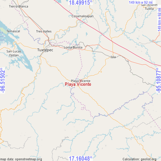
Playa Vicente GPS coordinates[2]
17° 49' 51.852" North, 95° 48' 42.804" West
| Map corner | latitude | longitude |
|---|---|---|
| Upper-left | 18.49915°, | -96.51502° |
| Center: | 17.83107°, | -95.81189° |
| Lower-right: | 17.16048°, | -95.10877° |
| Map W x H: | 148.8×148.8 km | = 92.5×92.5mi |
| max Lat: | 32.7° ⇑80.2% North |
| Playa Vicente: | 17.83107° |
| min Lat: | ⇓19.8% South 14.53588° |
| min Long | Playa Vicente | max Long |
| -117.105° | -95.81189° | -86.73105° |
| W 82.7%⇐ | ⇒17.3% E |
Elevation
Elevation of Playa Vicente is 57 m = 187 ft, and this is 1196.7 m = 3926 ft below average elevation for this country.
| Max E: |
3497 m = 11473 ft | 83.4% |
| Avg. | 1253.7 m = 4113 ft | |
| Playa Vicente | 57 m = 187 ft | |
Min E: |
-1 m = -3 ft | 16.6% |
See also: Mexico elevation on elevation.city.
Geographical zone
Playa Vicente is located in North Torrid zone (between Equator and Tropic of Cancer). Distance of this Northern Tropic circle is 623.3 km =387.3 mi to North.| Distance of | km | miles | from Playa Vicente |
|---|---|---|---|
| North Pole | 8024.4 | 4986.1 | to North |
| Arctic Circle | 5418.5 | 3366.9 | to North |
| Tropic Cancer | 623.3 | 387.3 | to North |
| Equator | 1982.6 | 1231.9 | to South |


Nearby cities:
15 places around Playa Vicente: (largest is in red/bold)
• Arenal Santa Ana
6.4 km =4 mi,  135°
135°
• Arroyo Limón
17.6 km =10.9 mi,  295°
295°
• Arroyo Zacate
11.6 km =7.2 mi,  172°
172°
• Chilapa del Carmen
5.4 km =3.4 mi, 173°
• El Nigromante
9.4 km =5.8 mi, 141°
• La Carlota
6.9 km =4.3 mi,  280°
280°
• La Nueva Era
14.7 km =9.1 mi,  178°
178°
• La Soledad
7.8 km =4.8 mi, 300°
• La Victoria
8.3 km =5.2 mi,  44°
44°
• Lealtad de Muñoz
13 km =8.1 mi,  67°
67°
• Mixtán
10.3 km =6.4 mi,  330°
330°
• Pueblo Nuevo Ojo de Agua
13.2 km =8.2 mi, 301°
• San Felipe
12.7 km =7.9 mi,  274°
274°
• Tomate Río Manso
12.6 km =7.8 mi,  210°
210°
• Tomatillo
15 km =9.3 mi, 165°
Sources, notices
• [Note1] Compared only with cities in Mexico existing in our database
• [Src1] Map data: © OpenStreetMap contributors (CC-BY-SA)
• [Src2] Other city data from geonames.org with taken over terms of usage.
• [Src3] Geographical zone / Annual Mean Temperature by Robert A. Rohde @ Wikipedia
