Guadalupe del Pedregal la Palma geodata
Guadalupe del Pedregal la Palma (State of Mexico) is a populated place; located in Mexico in America/Mexico_City (GMT-6) time zone. With population of 533 people, there are 15888 cities with bigger population in this country. Compared to other cities in Mexico, 50.3% of cities are located further ↑North; 65.3% of cities are located further →East and 97.1% of cities have lower elevation than Guadalupe del Pedregal la Palma. Note1
Current local time in Guadalupe del Pedregal la Palma:
08:32 AM, WednesdayDifference from your time zone: hours


Guadalupe del Pedregal la Palma GPS coordinates[2]
19° 40' 37.38" North, 100° 6' 43.128" West
| Map corner | latitude | longitude |
|---|---|---|
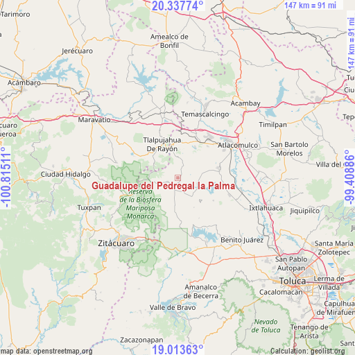
| Upper-left | 20.33774°, | -100.81511° |
| Center: | 19.67705°, | -100.11198° |
| Lower-right: | 19.01363°, | -99.40886° |
| Map W x H: | 147.2×147.2 km | = 91.5×91.5mi |
| max Lat: | 32.7° ⇑50.3% North |
| Guadalupe del Pedregal la Palma: | 19.67705° |
| min Lat: | ⇓49.7% South 14.53588° |
| min Long | Guadalupe del P | max Long |
| -117.105° | -100.11198° | -86.73105° |
| W 34.7%⇐ | ⇒65.3% E |
Elevation
Elevation of Guadalupe del Pedregal la Palma is 2684 m = 8806 ft, and this is 1430.3 m = 4693 ft above average elevation for this country.
| Max E: |
3497 m = 11473 ft | 2.9% |
| Guadalupe del Pedregal la Palma | 2684 m 8806 ft | |
| Avg. | 1253.7 m = 4113 ft | |
Min E: |
-1 m = -3 ft | 97.1% |
See also: Mexico elevation on elevation.city.
Geographical zone
Guadalupe del Pedregal la Palma is located in North Torrid zone (between Equator and Tropic of Cancer). Distance of this Northern Tropic circle is 418 km =259.7 mi to North.| Distance of | km | miles | from Guadalupe del Pedregal la Palma |
|---|---|---|---|
| North Pole | 7819.2 | 4858.6 | to North |
| Arctic Circle | 5213.3 | 3239.4 | to North |
| Tropic Cancer | 418 | 259.7 | to North |
| Equator | 2187.9 | 1359.5 | to South |


Nearby cities:
15 places around Guadalupe del Pedregal la Palma: (largest is in red/bold)
• Cedro de la Manzana
1.7 km =1.1 mi,  344°
344°
• Concepción del Monte
5.3 km =3.3 mi,  237°
237°
• Concepción la Venta
4.5 km =2.8 mi,  290°
290°
• Ejido la Soledad
3.6 km =2.2 mi,  170°
170°
• El Salto la Venta (Barrio el Salto)
3.9 km =2.4 mi,  312°
312°
• El Valerio
3.1 km =1.9 mi,  154°
154°
• Fábrica Concepción
5.4 km =3.4 mi,  207°
207°
• Fábrica Pueblo Nuevo
3.9 km =2.4 mi,  273°
273°
• Jesús Carranza
3.2 km =2 mi,  23°
23°
• San Francisco Solo
5.1 km =3.2 mi, 24°
• San José del Rincón Centro
4.6 km =2.9 mi,  248°
248°
• San Miguel Agua Bendita
6.2 km =3.9 mi, 146°
• San Miguel del Centro
4.9 km =3 mi,  3°
3°
• Santa Cruz del Rincón
1.1 km =0.7 mi,  187°
187°
• Santa Cruz del Tejocote
5.9 km =3.7 mi, 273°
Sources, notices
• [Note1] Compared only with cities in Mexico existing in our database
• [Src1] Map data: © OpenStreetMap contributors (CC-BY-SA)
• [Src2] Other city data from geonames.org with taken over terms of usage.
• [Src3] Geographical zone / Annual Mean Temperature by Robert A. Rohde @ Wikipedia
