Kuching geodata
Kuching (Sarawak) is a seat of a first-order administrative division; located in Malaysia in Asia/Kuching (GMT+8) time zone. With population of 570,407 people, there are 7 cities with bigger population in this country. Compared to other cities in Malaysia, 96.6% of cities are located further ↑North; 82% of cities are located further ←West and 77% of cities have higher elevation than Kuching. Note1


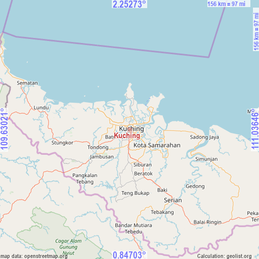
Kuching GPS coordinates[2]
1° 33' 0" North, 110° 19' 59.988" East
| Map corner | latitude | longitude |
|---|---|---|
| Upper-left | 2.25273°, | 109.63021° |
| Center: | 1.55°, | 110.33333° |
| Lower-right: | 0.84703°, | 111.03646° |
| Map W x H: | 156.3×156.3 km | = 97.1×97.1mi |
| max Lat: | 6.88732° ⇑96.6% North |
| Kuching: | 1.55° |
| min Lat: | ⇓3.4% South 1.24722° |
| min Long | Kuching | max Long |
| 99.68252° | 110.33333° | 118.61119° |
| W 82%⇐ | ⇒18% E |
Elevation
Elevation of Kuching is 8 m = 26 ft, and this is 36.7 m = 120 ft below average elevation for this country.
| Max E: |
1488 m = 4882 ft | 77% |
| Avg. | 44.7 m = 147 ft | |
| Kuching | 8 m = 26 ft | |
Min E: |
0 m = 0 ft | 23% |
See also: Kuching elevation on elevation.city.
Geographical zone
Kuching is located in North Torrid zone (between Equator and Tropic of Cancer). Distance of Equator is 172.3 km =107.1 mi to South.| Distance of | km | miles | from Kuching |
|---|---|---|---|
| North Pole | 9834.7 | 6111 | to North |
| Arctic Circle | 7228.8 | 4491.8 | to North |
| Tropic Cancer | 2433.6 | 1512.2 | to North |
| Equator | 172.3 | 107.1 | to South |


Nearby cities:
7 places around Kuching: (largest is in red/bold)
• Bintulu
349.7 km =217.3 mi,  59°
59°
• Data Kakus
385.6 km =239.6 mi,  71°
71°
• Kapit
293.1 km =182.1 mi,  80°
80°
• Mukah
246 km =152.9 mi,  52°
52°
• Sarikei
145.8 km =90.6 mi, 64°
• Sibu
184.7 km =114.8 mi, 63°
• Simanggang
128.9 km =80.1 mi,  105°
105°
Sources, notices
• [Note1] Compared only with cities in Malaysia existing in our database
• [Src1] Map data: © OpenStreetMap contributors (CC-BY-SA)
• [Src2] Other city data from geonames.org with taken over terms of usage.
• [Src3] Geographical zone / Annual Mean Temperature by Robert A. Rohde @ Wikipedia
