Bintulu geodata
Bintulu (Sarawak) is a populated place; located in Malaysia in Asia/Kuching (GMT+8) time zone. With population of 151,617 people, there are 29 cities with bigger population in this country. Compared to other cities in Malaysia, 60.7% of cities are located further ↑North; 85.4% of cities are located further ←West and 77% of cities have higher elevation than Bintulu. Note1


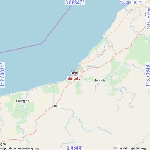
Bintulu GPS coordinates[2]
3° 10' 0.012" North, 113° 1' 59.988" East
| Map corner | latitude | longitude |
|---|---|---|
| Upper-left | 3.86847°, | 112.33021° |
| Center: | 3.16667°, | 113.03333° |
| Lower-right: | 2.4644°, | 113.73646° |
| Map W x H: | 156.1×156.1 km | = 97×97mi |
| max Lat: | 6.88732° ⇑60.7% North |
| Bintulu: | 3.16667° |
| min Lat: | ⇓39.3% South 1.24722° |
| min Long | Bintulu | max Long |
| 99.68252° | 113.03333° | 118.61119° |
| W 85.4%⇐ | ⇒14.6% E |
Elevation
Elevation of Bintulu is 8 m = 26 ft, and this is 36.7 m = 120 ft below average elevation for this country.
| Max E: |
1488 m = 4882 ft | 77% |
| Avg. | 44.7 m = 147 ft | |
| Bintulu | 8 m = 26 ft | |
Min E: |
0 m = 0 ft | 23% |
See also: Bintulu elevation on elevation.city.
Geographical zone
Bintulu is located in North Torrid zone (between Equator and Tropic of Cancer). Distance of Equator is 352.1 km =218.8 mi to South.| Distance of | km | miles | from Bintulu |
|---|---|---|---|
| North Pole | 9655 | 5999.3 | to North |
| Arctic Circle | 7049.1 | 4380.1 | to North |
| Tropic Cancer | 2253.8 | 1400.4 | to North |
| Equator | 352.1 | 218.8 | to South |


Nearby cities:
15 places around Bintulu: (largest is in red/bold)
• Bandar Labuan
342.3 km =212.7 mi,  46°
46°
• Batu Niah
106.2 km =66 mi, 48°
• Data Kakus
86.7 km =53.9 mi,  131°
131°
• Kapit
130.7 km =81.2 mi,  184°
184°
• Labuan
339.9 km =211.2 mi, 46°
• Lawas
323.9 km =201.3 mi, 54°
• Lidung Jelo
203 km =126.1 mi,  106°
106°
• Limbang
280.3 km =174.2 mi, 51°
• Long Ampan Aing or Abanang
197.5 km =122.7 mi, 106°
• Marudi
181.8 km =113 mi, 51°
• Miri
173.5 km =107.8 mi,  37°
37°
• Mukah
108.9 km =67.7 mi,  253°
253°
• Sarikei
205 km =127.4 mi,  235°
235°
• Sibu
166 km =103.1 mi,  234°
234°
• Simanggang
276.4 km =171.7 mi,  219°
219°
Sources, notices
• [Note1] Compared only with cities in Malaysia existing in our database
• [Src1] Map data: © OpenStreetMap contributors (CC-BY-SA)
• [Src2] Other city data from geonames.org with taken over terms of usage.
• [Src3] Geographical zone / Annual Mean Temperature by Robert A. Rohde @ Wikipedia
