Kapit geodata
Kapit (Sarawak) is a populated place; located in Malaysia in Asia/Kuching (GMT+8) time zone. With population of 15,771 people, there are 138 cities with bigger population in this country. Compared to other cities in Malaysia, 91.6% of cities are located further ↑North; 84.8% of cities are located further ←West and 83.1% of cities have lower elevation than Kapit. Note1


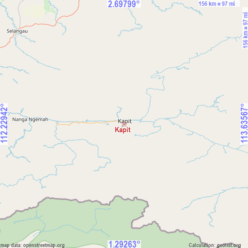
Kapit GPS coordinates[2]
1° 59' 43.656" North, 112° 55' 57.144" East
| Map corner | latitude | longitude |
|---|---|---|
| Upper-left | 2.69799°, | 112.22942° |
| Center: | 1.99546°, | 112.93254° |
| Lower-right: | 1.29263°, | 113.63567° |
| Map W x H: | 156.3×156.3 km | = 97.1×97.1mi |
| max Lat: | 6.88732° ⇑91.6% North |
| Kapit: | 1.99546° |
| min Lat: | ⇓8.4% South 1.24722° |
| min Long | Kapit | max Long |
| 99.68252° | 112.93254° | 118.61119° |
| W 84.8%⇐ | ⇒15.2% E |
Elevation
Elevation of Kapit is 43 m = 141 ft, and this is 1.7 m = 6 ft below average elevation for this country.
| Max E: |
1488 m = 4882 ft | 16.9% |
| Avg. | 44.7 m = 147 ft | |
| Kapit | 43 m = 141 ft | |
Min E: |
0 m = 0 ft | 83.1% |
See also: Malaysia elevation on elevation.city.
Geographical zone
Kapit is located in North Torrid zone (between Equator and Tropic of Cancer). Distance of Equator is 221.9 km =137.9 mi to South.| Distance of | km | miles | from Kapit |
|---|---|---|---|
| North Pole | 9785.2 | 6080.2 | to North |
| Arctic Circle | 7179.3 | 4461 | to North |
| Tropic Cancer | 2384 | 1481.3 | to North |
| Equator | 221.9 | 137.9 | to South |


Nearby cities:
14 places around Kapit: (largest is in red/bold)
• Batu Niah
220.2 km =136.8 mi,  24°
24°
• Bintulu
130.7 km =81.2 mi,  4°
4°
• Data Kakus
106.1 km =65.9 mi,  46°
46°
• Kuching
293.1 km =182.1 mi,  260°
260°
• Lawas
420.7 km =261.4 mi,  40°
40°
• Lidung Jelo
218.4 km =135.7 mi,  70°
70°
• Limbang
382.7 km =237.8 mi, 36°
• Long Ampan Aing or Abanang
213.5 km =132.7 mi, 69°
• Marudi
287.7 km =178.8 mi,  32°
32°
• Miri
292 km =181.4 mi, 23°
• Mukah
136.8 km =85 mi,  316°
316°
• Sarikei
157.9 km =98.1 mi,  274°
274°
• Sibu
128.5 km =79.8 mi,  285°
285°
• Simanggang
184.3 km =114.5 mi,  243°
243°
Sources, notices
• [Note1] Compared only with cities in Malaysia existing in our database
• [Src1] Map data: © OpenStreetMap contributors (CC-BY-SA)
• [Src2] Other city data from geonames.org with taken over terms of usage.
• [Src3] Geographical zone / Annual Mean Temperature by Robert A. Rohde @ Wikipedia
