Subang Jaya geodata
Subang Jaya (Selangor) is a section of populated place; located in Malaysia in Asia/Kuala_Lumpur (GMT+8) time zone. With population of 708,296 people, there are 5 cities with bigger population in this country. Compared to other cities in Malaysia, 64% of cities are located further ↑North; 63.5% of cities are located further →East and 80.9% of cities have lower elevation than Subang Jaya. Note1


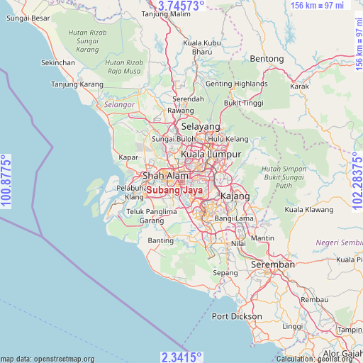
Subang Jaya GPS coordinates[2]
3° 2' 37.824" North, 101° 34' 50.232" East
| Map corner | latitude | longitude |
|---|---|---|
| Upper-left | 3.74573°, | 100.8775° |
| Center: | 3.04384°, | 101.58062° |
| Lower-right: | 2.3415°, | 102.28375° |
| Map W x H: | 156.1×156.1 km | = 97×97mi |
| max Lat: | 6.88732° ⇑64% North |
| Subang Jaya: | 3.04384° |
| min Lat: | ⇓36% South 1.24722° |
| min Long | Subang Jaya | max Long |
| 99.68252° | 101.58062° | 118.61119° |
| W 36.5%⇐ | ⇒63.5% E |
Elevation
Elevation of Subang Jaya is 41 m = 135 ft, and this is 3.7 m = 12 ft below average elevation for this country.
| Max E: |
1488 m = 4882 ft | 19.1% |
| Avg. | 44.7 m = 147 ft | |
| Subang Jaya | 41 m = 135 ft | |
Min E: |
0 m = 0 ft | 80.9% |
See also: Subang Jaya elevation on elevation.city.
Geographical zone
Subang Jaya is located in North Torrid zone (between Equator and Tropic of Cancer). Distance of Equator is 338.4 km =210.3 mi to South.| Distance of | km | miles | from Subang Jaya |
|---|---|---|---|
| North Pole | 9668.6 | 6007.8 | to North |
| Arctic Circle | 7062.7 | 4388.6 | to North |
| Tropic Cancer | 2267.5 | 1409 | to North |
| Equator | 338.4 | 210.3 | to South |


Nearby cities:
15 places around Subang Jaya: (largest is in red/bold)
• Ampang
23.8 km =14.8 mi,  60°
60°
• Banting
27.1 km =16.8 mi,  198°
198°
• Jenjarum
21.3 km =13.2 mi,  206°
206°
• Kampong Baharu Balakong
18.8 km =11.7 mi,  93°
93°
• Kampung Baru Subang
12.9 km =8 mi,  336°
336°
• Klang
15.3 km =9.5 mi,  267°
267°
• Kuala Lumpur
16 km =9.9 mi,  47°
47°
• Kuang
24.1 km =15 mi,  352°
352°
• Ladang Seri Kundang
27.7 km =17.2 mi, 345°
• Pelabuhan Klang
21.4 km =13.3 mi,  256°
256°
• Petaling Jaya
7.6 km =4.7 mi,  22°
22°
• Putra Heights
5.7 km =3.5 mi,  189°
189°
• Putrajaya
17.2 km =10.7 mi,  134°
134°
• Semenyih
30.9 km =19.2 mi,  109°
109°
• Shah Alam
7 km =4.3 mi,  310°
310°
Sources, notices
• [Note1] Compared only with cities in Malaysia existing in our database
• [Src1] Map data: © OpenStreetMap contributors (CC-BY-SA)
• [Src2] Other city data from geonames.org with taken over terms of usage.
• [Src3] Geographical zone / Annual Mean Temperature by Robert A. Rohde @ Wikipedia
