Banting geodata
Banting (Selangor) is a populated place; located in Malaysia in Asia/Kuala_Lumpur (GMT+8) time zone. With population of 48,240 people, there are 68 cities with bigger population in this country. Compared to other cities in Malaysia, 70.2% of cities are located further ↑North; 68% of cities are located further →East and 70.8% of cities have higher elevation than Banting. Note1


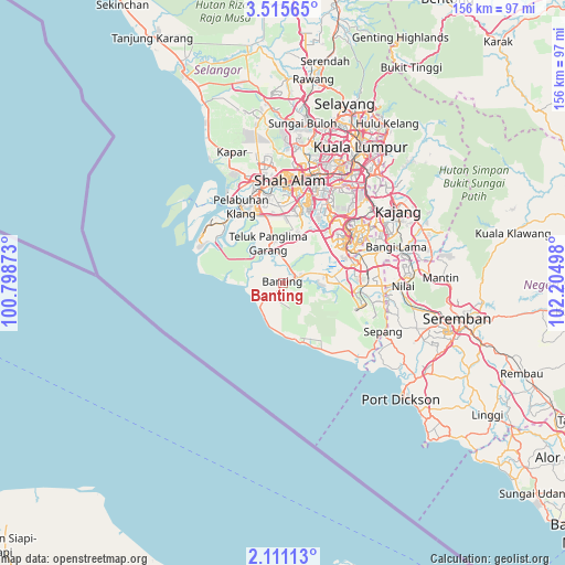
Banting GPS coordinates[2]
2° 48' 48.96" North, 101° 30' 6.66" East
| Map corner | latitude | longitude |
|---|---|---|
| Upper-left | 3.51565°, | 100.79873° |
| Center: | 2.8136°, | 101.50185° |
| Lower-right: | 2.11113°, | 102.20498° |
| Map W x H: | 156.2×156.2 km | = 97.1×97.1mi |
| max Lat: | 6.88732° ⇑70.2% North |
| Banting: | 2.8136° |
| min Lat: | ⇓29.8% South 1.24722° |
| min Long | Banting | max Long |
| 99.68252° | 101.50185° | 118.61119° |
| W 32%⇐ | ⇒68% E |
Elevation
Elevation of Banting is 9 m = 30 ft, and this is 35.7 m = 117 ft below average elevation for this country.
| Max E: |
1488 m = 4882 ft | 70.8% |
| Avg. | 44.7 m = 147 ft | |
| Banting | 9 m = 30 ft | |
Min E: |
0 m = 0 ft | 29.2% |
See also: Banting elevation on elevation.city.
Geographical zone
Banting is located in North Torrid zone (between Equator and Tropic of Cancer). Distance of Equator is 312.8 km =194.4 mi to South.| Distance of | km | miles | from Banting |
|---|---|---|---|
| North Pole | 9694.2 | 6023.7 | to North |
| Arctic Circle | 7088.3 | 4404.5 | to North |
| Tropic Cancer | 2293.1 | 1424.9 | to North |
| Equator | 312.8 | 194.4 | to South |


Nearby cities:
15 places around Banting: (largest is in red/bold)
• Bagan Pulau Ketam
34.5 km =21.4 mi,  310°
310°
• Jenjarum
6.6 km =4.1 mi,  353°
353°
• Kampong Baharu Balakong
36.8 km =22.9 mi,  48°
48°
• Kampung Baharu Nilai
32.8 km =20.4 mi,  91°
91°
• Kampung Baru Subang
37.6 km =23.4 mi,  5°
5°
• Klang
25.6 km =15.9 mi, 345°
• Pelabuhan Klang
24 km =14.9 mi,  329°
329°
• Petaling Jaya
34.7 km =21.6 mi,  19°
19°
• Putra Heights
21.5 km =13.4 mi, 21°
• Putrajaya
25 km =15.5 mi,  57°
57°
• Sepang
30.6 km =19 mi,  115°
115°
• Shah Alam
30.4 km =18.9 mi, 6°
• Subang Jaya
27.1 km =16.8 mi, 18°
• Sungai Pelek New Village
28.6 km =17.8 mi,  129°
129°
• Tanjung Sepat
18.6 km =11.6 mi,  158°
158°
Sources, notices
• [Note1] Compared only with cities in Malaysia existing in our database
• [Src1] Map data: © OpenStreetMap contributors (CC-BY-SA)
• [Src2] Other city data from geonames.org with taken over terms of usage.
• [Src3] Geographical zone / Annual Mean Temperature by Robert A. Rohde @ Wikipedia
