Putrajaya geodata
Putrajaya is a seat of government of a political entity; located in Malaysia in Asia/Kuala_Lumpur (GMT+8) time zone. With population of 50,000 people, there are 65 cities with bigger population in this country. Compared to other cities in Malaysia, 68% of cities are located further ↑North; 61.2% of cities are located further →East and 76.4% of cities have lower elevation than Putrajaya. Note1


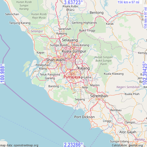
Putrajaya GPS coordinates[2]
2° 56' 6.972" North, 101° 41' 28.032" East
| Map corner | latitude | longitude |
|---|---|---|
| Upper-left | 3.63723°, | 100.988° |
| Center: | 2.93527°, | 101.69112° |
| Lower-right: | 2.23286°, | 102.39425° |
| Map W x H: | 156.2×156.2 km | = 97.1×97.1mi |
| max Lat: | 6.88732° ⇑68% North |
| Putrajaya: | 2.93527° |
| min Lat: | ⇓32% South 1.24722° |
| min Long | Putrajaya | max Long |
| 99.68252° | 101.69112° | 118.61119° |
| W 38.8%⇐ | ⇒61.2% E |
Elevation
Elevation of Putrajaya is 35 m = 115 ft, and this is 9.7 m = 32 ft below average elevation for this country.
| Max E: |
1488 m = 4882 ft | 23.6% |
| Avg. | 44.7 m = 147 ft | |
| Putrajaya | 35 m = 115 ft | |
Min E: |
0 m = 0 ft | 76.4% |
See also: Putrajaya elevation on elevation.city.
Geographical zone
Putrajaya is located in North Torrid zone (between Equator and Tropic of Cancer). Distance of Equator is 326.4 km =202.8 mi to South.| Distance of | km | miles | from Putrajaya |
|---|---|---|---|
| North Pole | 9680.7 | 6015.3 | to North |
| Arctic Circle | 7074.8 | 4396.1 | to North |
| Tropic Cancer | 2279.5 | 1416.4 | to North |
| Equator | 326.4 | 202.8 | to South |


Nearby cities:
15 places around Putrajaya: (largest is in red/bold)
• Ampang
25.3 km =15.7 mi,  19°
19°
• Banting
25 km =15.5 mi,  237°
237°
• Jenjarum
22.9 km =14.2 mi,  252°
252°
• Kampong Baharu Balakong
12.7 km =7.9 mi,  30°
30°
• Kampung Baharu Nilai
18.8 km =11.7 mi,  141°
141°
• Kampung Baru Subang
29.6 km =18.4 mi,  323°
323°
• Klang
29.7 km =18.5 mi,  292°
292°
• Kuala Lumpur
22.9 km =14.2 mi,  358°
358°
• Petaling Jaya
21.3 km =13.2 mi,  333°
333°
• Putra Heights
14.7 km =9.1 mi,  296°
296°
• Semenyih
17 km =10.6 mi,  83°
83°
• Sepang
27.7 km =17.2 mi,  166°
166°
• Shah Alam
24.2 km =15 mi,  313°
313°
• Subang Jaya
17.2 km =10.7 mi, 314°
• Sungai Pelek New Village
31.7 km =19.7 mi,  178°
178°
Sources, notices
• [Note1] Compared only with cities in Malaysia existing in our database
• [Src1] Map data: © OpenStreetMap contributors (CC-BY-SA)
• [Src2] Other city data from geonames.org with taken over terms of usage.
• [Src3] Geographical zone / Annual Mean Temperature by Robert A. Rohde @ Wikipedia
