Chimoio geodata
Chimoio (Manica) is a seat of a first-order administrative division; located in Mozambique in Africa/Maputo (GMT+2) time zone. With population of 256,936 people, there are 4 cities with bigger population in this country. Compared to other cities in Mozambique, 53.8% of cities are located further ↑North; 76.9% of cities are located further →East and 92.3% of cities have lower elevation than Chimoio. Note1


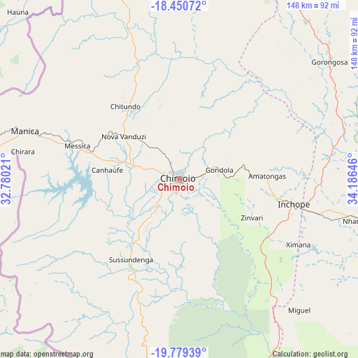
Chimoio GPS coordinates[2]
19° 6' 59.004" South, 33° 28' 59.988" East
| Map corner | latitude | longitude |
|---|---|---|
| Upper-left | -18.45072°, | 32.78021° |
| Center: | -19.11639°, | 33.48333° |
| Lower-right: | -19.77939°, | 34.18646° |
| Map W x H: | 147.7×147.7 km | = 91.8×91.8mi |
| max Lat: | -11.31667° ⇑53.8% North |
| Chimoio: | -19.11639° |
| min Lat: | ⇓46.2% South -25.96553° |
| min Long | Chimoio | max Long |
| 31.99528° | 33.48333° | 40.73583° |
| W 23.1%⇐ | ⇒76.9% E |
Elevation
Elevation of Chimoio is 709 m = 2326 ft, and this is 489.5 m = 1606 ft above average elevation for this country.
| Max E: |
1349 m = 4426 ft | 7.7% |
| Chimoio | 709 m 2326 ft | |
| Avg. | 219.5 m = 720 ft | |
Min E: |
4 m = 13 ft | 92.3% |
See also: Chimoio elevation on elevation.city.
Geographical zone
Chimoio is located in South Torrid zone (between Equator and Tropic of Capricorn). Distance of this Southern Tropic circle is 480.4 km =298.5 mi to South.| Distance of | km | miles | from Chimoio |
|---|---|---|---|
| Equator | 2125.5 | 1320.7 | to North |
| Tropic Capricorn | 480.4 | 298.5 | to South |
| Antarctic Circle | 5275.6 | 3278.1 | to South |
| South Pole | 7881.5 | 4897.3 | to South |


Nearby cities:
5 places around Chimoio: (largest is in red/bold)
• Beira
163.5 km =101.6 mi,  119°
119°
• Chinde
318.7 km =198 mi,  79°
79°
• Dondo
143.1 km =88.9 mi,  112°
112°
• Quelimane
384.5 km =238.9 mi,  69°
69°
• Tete
329.3 km =204.6 mi,  1°
1°
Sources, notices
• [Note1] Compared only with cities in Mozambique existing in our database
• [Src1] Map data: © OpenStreetMap contributors (CC-BY-SA)
• [Src2] Other city data from geonames.org with taken over terms of usage.
• [Src3] Geographical zone / Annual Mean Temperature by Robert A. Rohde @ Wikipedia
