Quelimane geodata
Quelimane (Zambézia) is a seat of a first-order administrative division; located in Mozambique in Africa/Maputo (GMT+2) time zone. With population of 188,964 people, there are 6 cities with bigger population in this country. Compared to other cities in Mozambique, 53.8% of cities are located further ↓South; 69.2% of cities are located further ←West and 84.6% of cities have higher elevation than Quelimane. Note1


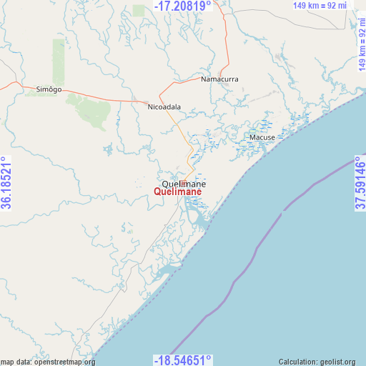
Quelimane GPS coordinates[2]
17° 52' 42.996" South, 36° 53' 17.988" East
| Map corner | latitude | longitude |
|---|---|---|
| Upper-left | -17.20819°, | 36.18521° |
| Center: | -17.87861°, | 36.88833° |
| Lower-right: | -18.54651°, | 37.59146° |
| Map W x H: | 148.8×148.8 km | = 92.5×92.5mi |
| max Lat: | -11.31667° ⇑46.2% North |
| Quelimane: | -17.87861° |
| min Lat: | ⇓53.8% South -25.96553° |
| min Long | Quelimane | max Long |
| 31.99528° | 36.88833° | 40.73583° |
| W 69.2%⇐ | ⇒30.8% E |
Elevation
Elevation of Quelimane is 9 m = 30 ft, and this is 210.5 m = 691 ft below average elevation for this country.
| Max E: |
1349 m = 4426 ft | 84.6% |
| Avg. | 219.5 m = 720 ft | |
| Quelimane | 9 m = 30 ft | |
Min E: |
4 m = 13 ft | 15.4% |
See also: Quelimane elevation on elevation.city.
Geographical zone
Quelimane is located in South Torrid zone (between Equator and Tropic of Capricorn). Distance of this Southern Tropic circle is 618 km =384 mi to South.| Distance of | km | miles | from Quelimane |
|---|---|---|---|
| Equator | 1987.9 | 1235.2 | to North |
| Tropic Capricorn | 618 | 384 | to South |
| Antarctic Circle | 5413.3 | 3363.7 | to South |
| South Pole | 8019.1 | 4982.8 | to South |


Nearby cities:
10 places around Quelimane: (largest is in red/bold)
• António Enes
369.5 km =229.6 mi,  60°
60°
• Beira
307 km =190.8 mi,  224°
224°
• Chimoio
384.5 km =238.9 mi,  249°
249°
• Chinde
90.3 km =56.1 mi,  210°
210°
• Cuamba
344 km =213.8 mi,  353°
353°
• Dondo
296.7 km =184.4 mi,  229°
229°
• Mandimba
413.8 km =257.1 mi,  341°
341°
• Mutuáli
334.7 km =208 mi,  2°
2°
• Nampula
398.2 km =247.4 mi,  39°
39°
• Tete
399.9 km =248.5 mi,  298°
298°
Sources, notices
• [Note1] Compared only with cities in Mozambique existing in our database
• [Src1] Map data: © OpenStreetMap contributors (CC-BY-SA)
• [Src2] Other city data from geonames.org with taken over terms of usage.
• [Src3] Geographical zone / Annual Mean Temperature by Robert A. Rohde @ Wikipedia
