Rano geodata
Rano (Kano) is a seat of a second-order administrative division; located in Nigeria in Africa/Lagos (GMT+1) time zone. With population of 17,972 people, there are 209 cities with bigger population in this country. Compared to other cities in Nigeria, 78.9% of cities are located further ↓South; 72.7% of cities are located further ←West and 87.3% of cities have lower elevation than Rano. Note1


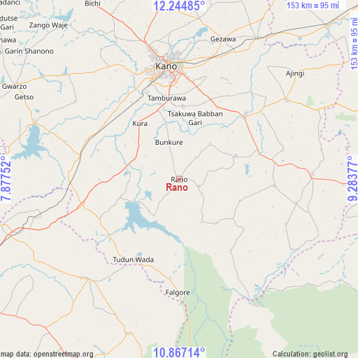
Rano GPS coordinates[2]
11° 33' 24.624" North, 8° 34' 50.34" East
| Map corner | latitude | longitude |
|---|---|---|
| Upper-left | 12.24485°, | 7.87752° |
| Center: | 11.55684°, | 8.58065° |
| Lower-right: | 10.86714°, | 9.28377° |
| Map W x H: | 153.2×153.2 km | = 95.2×95.2mi |
| max Lat: | 13.7543° ⇑21.1% North |
| Rano: | 11.55684° |
| min Lat: | ⇓78.9% South 4.31231° |
| min Long | Rano | max Long |
| 2.73333° | 8.58065° | 14.46552° |
| W 72.7%⇐ | ⇒27.3% E |
Elevation
Elevation of Rano is 526 m = 1726 ft, and this is 229.5 m = 753 ft above average elevation for this country.
| Max E: |
1599 m = 5246 ft | 12.7% |
| Rano | 526 m 1726 ft | |
| Avg. | 296.5 m = 973 ft | |
Min E: |
2 m = 7 ft | 87.3% |
See also: Nigeria elevation on elevation.city.
Geographical zone
Rano is located in North Torrid zone (between Equator and Tropic of Cancer). Distance of Equator is 1285 km =798.5 mi to South.| Distance of | km | miles | from Rano |
|---|---|---|---|
| North Pole | 8722.1 | 5419.7 | to North |
| Arctic Circle | 6116.2 | 3800.4 | to North |
| Tropic Cancer | 1320.9 | 820.8 | to North |
| Equator | 1285 | 798.5 | to South |


Nearby cities:
15 places around Rano: (largest is in red/bold)
• Bebeji
36.8 km =22.9 mi,  289°
289°
• Bunkure
16.4 km =10.2 mi,  344°
344°
• Burumburum
24.1 km =15 mi,  139°
139°
• Dan Gora
46.7 km =29 mi,  267°
267°
• Dawakin Kudu
31.2 km =19.4 mi,  3°
3°
• Garko
26.4 km =16.4 mi,  66°
66°
• Garun Malam
27.1 km =16.8 mi,  301°
301°
• Kibiya
9.3 km =5.8 mi,  110°
110°
• Kumbotso
38 km =23.6 mi,  347°
347°
• Kura
29.3 km =18.2 mi,  324°
324°
• Madobi
40.2 km =25 mi,  307°
307°
• Sumaila
41 km =25.5 mi,  94°
94°
• Tudun Wada
39.5 km =24.5 mi,  209°
209°
• Warawa
36.8 km =22.9 mi,  20°
20°
• Wudil
40.2 km =25 mi,  45°
45°
Sources, notices
• [Note1] Compared only with cities in Nigeria existing in our database
• [Src1] Map data: © OpenStreetMap contributors (CC-BY-SA)
• [Src2] Other city data from geonames.org with taken over terms of usage.
• [Src3] Geographical zone / Annual Mean Temperature by Robert A. Rohde @ Wikipedia
