Kibiya geodata
Kibiya (Kano) is a seat of a second-order administrative division; located in Nigeria in Africa/Lagos (GMT+1) time zone. With population of 8,500 people, there are 371 cities with bigger population in this country. Compared to other cities in Nigeria, 78.1% of cities are located further ↓South; 73.4% of cities are located further ←West and 85.2% of cities have lower elevation than Kibiya. Note1


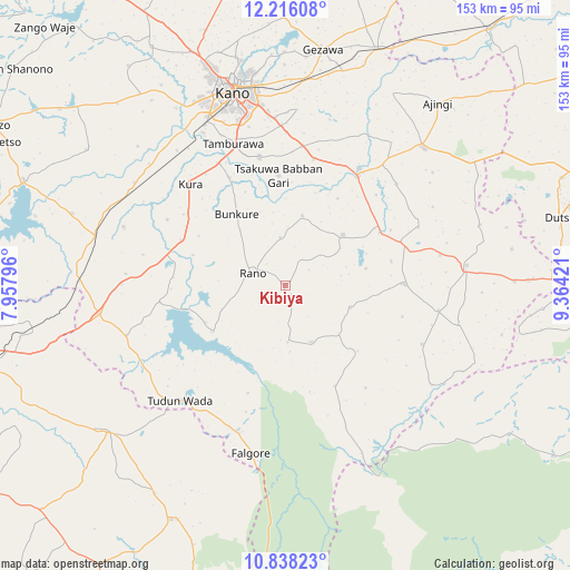
Kibiya GPS coordinates[2]
11° 31' 40.8" North, 8° 39' 39.888" East
| Map corner | latitude | longitude |
|---|---|---|
| Upper-left | 12.21608°, | 7.95796° |
| Center: | 11.528°, | 8.66108° |
| Lower-right: | 10.83823°, | 9.36421° |
| Map W x H: | 153.2×153.2 km | = 95.2×95.2mi |
| max Lat: | 13.7543° ⇑21.9% North |
| Kibiya: | 11.528° |
| min Lat: | ⇓78.1% South 4.31231° |
| min Long | Kibiya | max Long |
| 2.73333° | 8.66108° | 14.46552° |
| W 73.4%⇐ | ⇒26.6% E |
Elevation
Elevation of Kibiya is 504 m = 1654 ft, and this is 207.5 m = 681 ft above average elevation for this country.
| Max E: |
1599 m = 5246 ft | 14.8% |
| Kibiya | 504 m 1654 ft | |
| Avg. | 296.5 m = 973 ft | |
Min E: |
2 m = 7 ft | 85.2% |
See also: Nigeria elevation on elevation.city.
Geographical zone
Kibiya is located in North Torrid zone (between Equator and Tropic of Cancer). Distance of Equator is 1281.8 km =796.5 mi to South.| Distance of | km | miles | from Kibiya |
|---|---|---|---|
| North Pole | 8725.3 | 5421.6 | to North |
| Arctic Circle | 6119.4 | 3802.4 | to North |
| Tropic Cancer | 1324.1 | 822.8 | to North |
| Equator | 1281.8 | 796.5 | to South |


Nearby cities:
15 places around Kibiya: (largest is in red/bold)
• Bebeji
46.2 km =28.7 mi,  289°
289°
• Bunkure
23.1 km =14.4 mi,  325°
325°
• Burumburum
16.7 km =10.4 mi,  155°
155°
• Dawakin Kudu
35.1 km =21.8 mi,  348°
348°
• Garko
20.6 km =12.8 mi,  48°
48°
• Garun Malam
36.2 km =22.5 mi,  298°
298°
• Kumbotso
43.8 km =27.2 mi,  336°
336°
• Kura
37.3 km =23.2 mi,  316°
316°
• Madobi
49.2 km =30.6 mi, 304°
• Rano
9.3 km =5.8 mi, 290°
• Sumaila
32.1 km =19.9 mi,  89°
89°
• Takai
49.1 km =30.5 mi,  83°
83°
• Tudun Wada
42.1 km =26.2 mi,  222°
222°
• Warawa
37.9 km =23.5 mi,  6°
6°
• Wudil
37.1 km =23.1 mi,  32°
32°
Sources, notices
• [Note1] Compared only with cities in Nigeria existing in our database
• [Src1] Map data: © OpenStreetMap contributors (CC-BY-SA)
• [Src2] Other city data from geonames.org with taken over terms of usage.
• [Src3] Geographical zone / Annual Mean Temperature by Robert A. Rohde @ Wikipedia
