Dan Gora geodata
Dan Gora (Kano) is a populated place; located in Nigeria in Africa/Lagos (GMT+1) time zone. With population of 7,907 people, there are 387 cities with bigger population in this country. Compared to other cities in Nigeria, 78.3% of cities are located further ↓South; 66.4% of cities are located further ←West and 91.5% of cities have lower elevation than Dan Gora. Note1


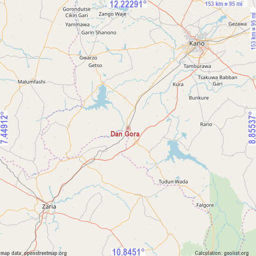
Dan Gora GPS coordinates[2]
11° 32' 5.46" North, 8° 9' 8.064" East
| Map corner | latitude | longitude |
|---|---|---|
| Upper-left | 12.22291°, | 7.44912° |
| Center: | 11.53485°, | 8.15224° |
| Lower-right: | 10.8451°, | 8.85537° |
| Map W x H: | 153.2×153.2 km | = 95.2×95.2mi |
| max Lat: | 13.7543° ⇑21.7% North |
| Dan Gora: | 11.53485° |
| min Lat: | ⇓78.3% South 4.31231° |
| min Long | Dan Gora | max Long |
| 2.73333° | 8.15224° | 14.46552° |
| W 66.4%⇐ | ⇒33.6% E |
Elevation
Elevation of Dan Gora is 576 m = 1890 ft, and this is 279.5 m = 917 ft above average elevation for this country.
| Max E: |
1599 m = 5246 ft | 8.5% |
| Dan Gora | 576 m 1890 ft | |
| Avg. | 296.5 m = 973 ft | |
Min E: |
2 m = 7 ft | 91.5% |
See also: Nigeria elevation on elevation.city.
Geographical zone
Dan Gora is located in North Torrid zone (between Equator and Tropic of Cancer). Distance of Equator is 1282.6 km =797 mi to South.| Distance of | km | miles | from Dan Gora |
|---|---|---|---|
| North Pole | 8724.5 | 5421.2 | to North |
| Arctic Circle | 6118.6 | 3801.9 | to North |
| Tropic Cancer | 1323.4 | 822.3 | to North |
| Equator | 1282.6 | 797 | to South |


Nearby cities:
15 places around Dan Gora: (largest is in red/bold)
• Bebeji
19 km =11.8 mi,  38°
38°
• Bunkure
46.1 km =28.6 mi,  66°
66°
• Garun Malam
29 km =18 mi,  54°
54°
• Gwarzo
48.6 km =30.2 mi,  330°
330°
• Ikara
40.8 km =25.4 mi,  168°
168°
• Kabo
35.8 km =22.2 mi,  3°
3°
• Karaye
31.4 km =19.5 mi, 331°
• Kiru
18.7 km =11.6 mi,  354°
354°
• Kura
39.8 km =24.7 mi, 48°
• Madobi
30.7 km =19.1 mi,  28°
28°
• Makarfi
34.4 km =21.4 mi,  239°
239°
• Rano
46.7 km =29 mi,  87°
87°
• Rimin Gado
49.2 km =30.6 mi,  12°
12°
• Rogo
36 km =22.4 mi,  273°
273°
• Tudun Wada
41.8 km =26 mi,  139°
139°
Sources, notices
• [Note1] Compared only with cities in Nigeria existing in our database
• [Src1] Map data: © OpenStreetMap contributors (CC-BY-SA)
• [Src2] Other city data from geonames.org with taken over terms of usage.
• [Src3] Geographical zone / Annual Mean Temperature by Robert A. Rohde @ Wikipedia
