Takai geodata
Takai (Kano) is a seat of a second-order administrative division; located in Nigeria in Africa/Lagos (GMT+1) time zone. With population of 10,748 people, there are 322 cities with bigger population in this country. Compared to other cities in Nigeria, 79% of cities are located further ↓South; 77.7% of cities are located further ←West and 78.6% of cities have lower elevation than Takai. Note1


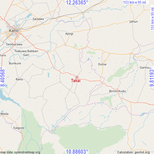
Takai GPS coordinates[2]
11° 34' 32.484" North, 9° 6' 31.68" East
| Map corner | latitude | longitude |
|---|---|---|
| Upper-left | 12.26365°, | 8.40568° |
| Center: | 11.57569°, | 9.1088° |
| Lower-right: | 10.88603°, | 9.81193° |
| Map W x H: | 153.2×153.2 km | = 95.2×95.2mi |
| max Lat: | 13.7543° ⇑21% North |
| Takai: | 11.57569° |
| min Lat: | ⇓79% South 4.31231° |
| min Long | Takai | max Long |
| 2.73333° | 9.1088° | 14.46552° |
| W 77.7%⇐ | ⇒22.3% E |
Elevation
Elevation of Takai is 458 m = 1503 ft, and this is 161.5 m = 530 ft above average elevation for this country.
| Max E: |
1599 m = 5246 ft | 21.4% |
| Takai | 458 m 1503 ft | |
| Avg. | 296.5 m = 973 ft | |
Min E: |
2 m = 7 ft | 78.6% |
See also: Nigeria elevation on elevation.city.
Geographical zone
Takai is located in North Torrid zone (between Equator and Tropic of Cancer). Distance of Equator is 1287.1 km =799.8 mi to South.| Distance of | km | miles | from Takai |
|---|---|---|---|
| North Pole | 8720 | 5418.4 | to North |
| Arctic Circle | 6114.1 | 3799.1 | to North |
| Tropic Cancer | 1318.8 | 819.5 | to North |
| Equator | 1287.1 | 799.8 | to South |


Nearby cities:
15 places around Takai: (largest is in red/bold)
• Ajingi
44.3 km =27.5 mi,  349°
349°
• Albasu
11.5 km =7.1 mi,  17°
17°
• Birnin Kudu
42.6 km =26.5 mi,  108°
108°
• Burumburum
46.7 km =29 mi,  243°
243°
• Dawakin Kudu
62.9 km =39.1 mi,  297°
297°
• Dutse
32.1 km =19.9 mi,  51°
51°
• Garko
34.3 km =21.3 mi,  283°
283°
• Gaya
33.7 km =20.9 mi,  339°
339°
• Kibiya
49.1 km =30.5 mi,  263°
263°
• Kiyawa
59 km =36.7 mi,  66°
66°
• Rano
57.6 km =35.8 mi,  267°
267°
• Samamiya
63.1 km =39.2 mi, 113°
• Sumaila
17.4 km =10.8 mi,  253°
253°
• Warawa
54.9 km =34.1 mi,  306°
306°
• Wudil
38.8 km =24.1 mi, 312°
Sources, notices
• [Note1] Compared only with cities in Nigeria existing in our database
• [Src1] Map data: © OpenStreetMap contributors (CC-BY-SA)
• [Src2] Other city data from geonames.org with taken over terms of usage.
• [Src3] Geographical zone / Annual Mean Temperature by Robert A. Rohde @ Wikipedia
